


|
||

|

|
|

|
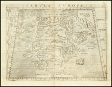
Tabula Europae II is a map of Spain & Portugal by Sebastian Munster, published in Basel in 1540, offering a detailed portrayal of the region as it was understood during Ptolemy’s era.
This cartographic work is anchored in mid-16th century Europe, a period marked by the gradual shift from medieval to modern paradigms in various fields of knowledge. Munster's map, being a part of his broader work the Geographia (1540), serves as a reflection of the geographical and topographical knowledge of the time. It displays a detailed enumeration of cities and territories within the Iberian Peninsula, drawing heavily from the Ptolemaic tradition while also incorporating contemporary Renaissance influences.
The map's detailed labeling of the cities and regions, from Flauionauia to Lusitania, presents an extensive catalog of locations, each carrying its distinct historical narrative. These designations offer insights into the evolving nature of geographical knowledge and its documentation during the Renaissance.
The incorporation of Ptolemaic principles in Tabula Europae II exemplifies the resurgence of classical knowledge, spurred by the humanistic currents of the Renaissance. Munster’s work is a confluence of ancient geographical traditions and the evolving methodologies of the 16th century.
In the broader historical narrative, the Iberian Peninsula’s depiction in Munster’s map is emblematic of a region that has been a significant theater of cultural, political, and economic interactions. The detailed representation of cities and regions underscores the peninsula’s multifaceted identity, shaped by the imprints of Roman, Visigothic, and Moorish civilizations. The map serves as a resource for understanding the complex tapestry of influences that have shaped the identities and boundaries within this European region.
Sebastian Münster (1488-1552) was a cosmographer and professor of Hebrew who taught at Tübingen, Heidelberg, and Basel. He settled in the latter in 1529 and died there, of plague, in 1552. Münster made himself the center of a large network of scholars from whom he obtained geographic descriptions, maps, and directions.
As a young man, Münster joined the Franciscan order, in which he became a priest. He then studied geography at Tübingen, graduating in 1518. He moved to Basel, where he published a Hebrew grammar, one of the first books in Hebrew published in Germany. In 1521 Münster moved again, to Heidelberg, where he continued to publish Hebrew texts and the first German-produced books in Aramaic. After converting to Protestantism in 1529, he took over the chair of Hebrew at Basel, where he published his main Hebrew work, a two-volume Old Testament with a Latin translation.
Münster published his first known map, a map of Germany, in 1525. Three years later, he released a treatise on sundials. In 1540, he published Geographia universalis vetus et nova, an updated edition of Ptolemy’s Geographia. In addition to the Ptolemaic maps, Münster added 21 modern maps. One of Münster’s innovations was to include one map for each continent, a concept that would influence Ortelius and other early atlas makers. The Geographia was reprinted in 1542, 1545, and 1552.
He is best known for his Cosmographia universalis, first published in 1544 and released in at least 35 editions by 1628. It was the first German-language description of the world and contained 471 woodcuts and 26 maps over six volumes. Many of the maps were taken from the Geographia and modified over time. The Cosmographia was widely used in the sixteenth and seventeenth centuries. The text, woodcuts, and maps all influenced geographical thought for generations.

![[ Tracking The Armies of Bonaparte and the English During The Peninsular Campaign ] New Map of Spain and Portugal By E. Mentelle, Member of Institute of Science at Paris, and P. G. Chanlaire, One of the Authors of the National Atlas](https://storage.googleapis.com/raremaps/img/small/99148.jpg)