|
||

|

|
|

|
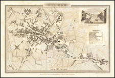
This 1851 town plan of Brighton, by renowned cartographer John Tallis, presents an exceptional representation of this bustling seaside resort, rendered in vibrant colors. The map details the town's layout, pinpointing landmarks such as Brighton College, railway stations, and a variety of buildings. It is further embellished by picturesque landscape vignettes in the upper portion, which provide a richly textured depiction of the town and its environs.
The map's creation coincides with a time of significant expansion for Brighton. The mid-19th century saw the town evolve from a fashionable seaside resort for the British elite into a thriving urban center. The arrival of the railways, as depicted in Tallis's map, was a transformative event, boosting tourism and facilitating the town's rapid growth. Brighton College, another notable feature of the map, was established in 1845 as one of England's first public schools, and its presence speaks to the town's burgeoning status.
John Tallis's work is renowned for its exquisite detail and decorative style. His emphasis on including local scenes and figures, as seen in the landscape vignettes of this map, adds a narrative dimension that transcends the strictly geographic. It offers viewers a sense of the local culture and character, enriching the overall portrayal of the town.
As a town plan, this representation of Brighton holds an important place within Tallis's oeuvre. While his body of work primarily includes regional maps, town plans appear less frequently, thus elevating their rarity and appeal. This particular plan of Brighton, with its combination of geographical detail, vibrant color, and decorative vignettes, exemplifies Tallis's distinct cartographic style. It offers both a detailed geographical record of Brighton's mid-19th-century layout and a rich visual narrative of its historical context.
John Tallis (1817-1876) was a British map publisher. Born in the Midlands, Tallis came to London in the 1840s. Tallis began his London career with a series of remarkable London street views. He began a partnership with a Frederick Tallis, possibly his brother, but their collaboration ended in 1849. For the Great Exhibition of 1851, Tallis published the Illustrated World Atlas, one of the last series of decorative world maps ever produced. The maps were engraved by John Rapkin, a skilled artisan. The maps were later reissued by the London Printing & Publishing Company, who left the Tallis imprint intact, thus ensuring his enduring fame. In 1858, he began publication of the popular Illustrated News of the World and National Portrait Gallery of Eminent Personages, selling it in 1861 (it ceased publication in 1863).
![[ Southwest England ] Des Koenigreichs England sudlicher Theil oder Cornwall, Devon Shire, Dorset S. Somerset. S. Bristol, Wilt S. Hamp S. Berk. S. Buckingham S. undd Monmouth S.](https://storage.googleapis.com/raremaps/img/small/103898.jpg)