|
||

|

|
|

|
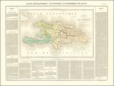
Fine example of this remarkable antique map that provides a captivating glimpse into the history and geography of Hispaniola, the island encompassing the modern-day nations of Haiti and the Dominican Republic. Created in 1722 and published in 1725, the map reflects the era's cartographic techniques and showcases the knowledge and exploration of the time.
The map includes excellent detail throughout includes realistic depictions of bays, mountains, islets, lagoons, forests, etc., which are combined with details of human development of the flourishing colony. Each town, plantation house, windmill, watermill, and sugar works is indicated, as well as gun emplacements, fortifications, anchorages, and government houses.
The map serves as a valuable historical artifact, not only for its geographical accuracy but also for the insights it offers into the local history of Hispaniola during an important period in its history. Between 1600 and 1750, Hispaniola experienced a tumultuous history of colonization, conflicts, and shifting colonial powers. The Spanish Empire was the first European power to establish a presence on the island, beginning with the arrival of Christopher Columbus in 1492. By the 1600s, however, the western portion of the island came under French control, while the eastern part remained under Spanish rule.
The French colony, known as Saint-Domingue, thrived during this period, mainly due to its vast sugar plantations and the forced labor of enslaved Africans. The island became the leading producer of sugar and one of the most profitable colonies in the French colonial empire. This map captures the influence of the French on the western side of Hispaniola, highlighting the numerous French settlements, plantations, and fortifications.
The map's creation was based on the memoirs of Mr. Frezier, adding an intriguing element to its historical significance. Mr. Frezier refers to Amédée-François Frezier, a French naval officer, engineer, and cartographer who visited Saint-Domingue and other parts of the Caribbean in the early 18th century. Frezier's memoirs provided valuable firsthand accounts of the geography, natural resources, and settlements of the region. His observations and insights contributed to a better understanding of the island's topography and its economic potential.
Covens & Mortier was one of the largest and most successful publishing firms in Dutch history and continued in business for over a century. Pierre Mortier the Elder (1661-1711) had obtained a privilege in 1690 to distribute the works of French geographers in the Netherlands. After his widow continued the business for several years, Cornelis (1699-1783) took over in 1719.
In 1721, Mortier forged a partnership with Johannes Covens (1697-1774), who had recently married Cornelis’ sister. They published under the joint name of Covens & Mortier. In 1774, upon the death of his father, Johannes Covens II (1722-1794) took over his father’s share. In 1778, the company changed its name to J. Covens & Zoon, or J. Covens & Son.
Covens II’s son, Cornelis (1764-1825), later inherited the business and brought Petrus Mortier IV back into the fold. Petrus was the great-grandson of Petrus Mortier I. From 1794, the business was called Mortier, Covens & Zoon, or Mortier, Covens, & Son.
The business specialized in publishing French geographers including Deslisle, Jaillot, Janssonius, and Sanson. They also published atlases, for example a 1725 reissue of Frederik de Wit’s Atlas Major and an atlas, with additions, from the works of Guillaume Delisle. There were also Covens & Mortier pocket atlases and town atlases. The company profited from acquiring plates from other geographers as well. For example, the purchased Pieter van der Aa’s plates in 1730. Finally, they also compiled a few maps in house. At their height, they had the largest collection of geographic prints ever assembled in Amsterdam.
![F.C. de Samana y Santiago. Sanchez [Santa Domingo]](https://storage.googleapis.com/raremaps/img/small/87648.jpg)
![[Columbus Discovering the Americas]](https://storage.googleapis.com/raremaps/img/small/82203.jpg)
![[ Hispaniola ]](https://storage.googleapis.com/raremaps/img/small/103795.jpg)