|
||

|

|
|

|
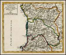
Map of the Roads of Portugal is a historically significant cartographic work published in London on January 1, 1811, by Aaron Arrowsmith, the Hydrographer to H.R.H. the Prince of Wales, located in Soho Square. Designed to assist military movements during the Peninsular War, this map provides a detailed depiction of the road network in Portugal, aiding the navigation of Portuguese and French troops across the diverse terrain of the country.
Created in the early stages of the Peninsular War, which commenced in 1807 with the invasion of Portugal by a combined French Imperial and Spanish force, this map played a crucial role in facilitating the movement and administration of troops in a country subjected to conflict. The occupation of Lisbon by French troops in November 1807 marked a turning point in the war, making the accurate mapping and understanding of Portuguese roads essential for French, Spanish, Portuguese, and British forces.
Arrowsmith based his map on the 1808 Lisbon-published Carta Militar das Principaes Estradas de Portugal. Arrowsmith has translated the map from French and Portuguese into English and the Note thus reads:
Figures on the Roads with an L. annexed are the number of Leagues from Town to Town.
Figures on.... D with an h. annexed are the hours a foot Courier is in Travelling.
This map, likes its Portuguese predecessor, sets itself apart with its inclusion of running hours for each subsection of road. This information was vital for military planners, offering insight into the speed at which troops could move across the country. Rather than focusing on rendering topography, the map prioritizes the practicalities of travel, providing valuable data for strategic decision-making.
The Map of the Roads of Portugal represents a remarkable cartographic piece from the Peninsular War era, shedding light on the strategic importance of accurate mapping during times of conflict. Its ability to convey information about travel times and its unique departure from topographical representation make it an intriguing artifact that provides valuable insight into the military operations and dynamics of the time.
A second edition was issued in 1812.
The Arrowsmiths were a cartographic dynasty which operated from the late-eighteenth century to the mid-nineteenth. The family business was founded by Aaron Arrowsmith (1750-1823), who was renowned for carefully prepared and meticulously updated maps, globes, and charts. He created many maps that covered multiple sheets and which were massive in total size. His spare yet exacting style was recognized around the world and mapmakers from other countries, especially the young country of the United States, sought his maps and charts as exemplars for their own work.
Aaron Arrowsmith was born in County Durham in 1750. He came to London for work around 1770, where he found employment as a surveyor for the city’s mapmakers. By 1790, he had set up his own shop which specialized in general charts. Arrowsmith had five premises in his career, most of which were located on or near Soho Square, a neighborhood the led him to rub shoulders with the likes of Joseph Banks, the naturalist, and Matthew Flinders, the hydrographer.
Through his business ties and employment at the Hydrographic Office, Arrowsmith made other important relationships with Alexander Dalrymple, the Hudson’s Bay Company, and others entities. In 1810 he became Hydrographer to the Prince of Wales and, in 1820, Hydrographer to the King.
Aaron Arrowsmith died in 1823, whereby the business and title of Hydrographer to the King passed to his sons, Aaron and Samuel, and, later, his nephew, John. Aaron Jr. (1802-1854) was a founder member of the Royal Geographical Society (RGS) and left the family business in 1832; instead, he enrolled at Oxford to study to become a minister. Samuel (1805-1839) joined Aaron as a partner in the business and they traded together until Aaron left for the ministry. Samuel died at age 34 in 1839; his brother presided over his funeral. The remaining stock and copper plates were bought at auction by John Arrowsmith, their cousin.
John (1790-1873) operated his own independent business after his uncle, Aaron Arrowsmith Sr., died. After 1839, John moved into the Soho premises of his uncle and cousins. John enjoyed considerable recognition in the geography and exploration community. Like Aaron Jr., John was a founder member of the RGS and would serve as its unofficial cartographer for 43 years. Several geographical features in Australia and Canada are named after him. He carried the title Hydrographer to Queen Victoria. He died in 1873 and the majority of his stock was eventually bought by Edward Stanford, who co-founded Stanford’s map shop, which is still open in Covent Garden, London today.
![[ Rare Imprint ] Hispania ex Archetypo Roderici Mendez Sylvae et variis Relationibus manuscriptis et impressis hujus Regni . . . .](https://storage.googleapis.com/raremaps/img/small/104150.jpg)
![Atlantic Islands [Azores, Madeira, Canary and Cape Verde]](https://storage.googleapis.com/raremaps/img/small/94761.jpg)