|
||

|

|
|

|
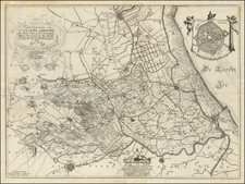
Finely colored example of Reiner & Iosua Ottens' sea chart of the North Sea, first engraved by Frederick De Wit.
The chart depicts the North Sea from Ameland in the Netherlands to the Straits of Dover and includes detailed information on the soundings, shoals, and rhumb lines of the region.
The rhumb lines, which are lines on the chart that show the direction of travel, are particularly detailed on this chart. The lines are shown in a web-like pattern that covers the entire chart, making it easy for sailors to navigate the North Sea. The chart also includes soundings, which are measurements of the depth of the sea, and shoals, which are underwater ridges or sandbars that can be dangerous for ships. The detailed information on the chart helped sailors navigate safely through the treacherous waters of the North Sea.
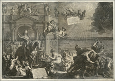
The chart is embellished with sailing ships and compass roses. The sailing ships give a sense of the bustling maritime traffic that was common in the region. The chart also includes a large allegorical cartouche, celebrating the Dutch trading empire around the world.
The Ottens brothers, Reiner and Joshua, operated a successful printing partnership in the mid-eighteenth century (fl. 1726-1765). They began the venture in 1726, publishing maps and other prints as “R & I Ottens.” They specialized in the reprinting of others’ work, especially Guillaume De L’Isle. In 1750, Reiner died; his soon, also Reiner, took his place, but the firm began listing their works as “Joshua & Reiner Ottens.” The firm lasted until Joshua’s death in 1765. Joshua’s widow, Johanna de Lindt, sold their remaining stock of plates in 1784.
![[ London To Portsmouth ] The Road from London to Portsmouth in com: Southamp: Actually Surveyed & Delineated . . . .](https://storage.googleapis.com/raremaps/img/small/98935.jpg)