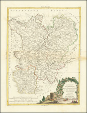
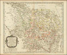
Uterque Rheni Circulus, Superior, et Inferior Electoralis, cum Palatinatu: Quos pro Parte includunt Westphalicus, Belgium Hispanicum, et Lotharingia quae Oriens
All of our maps are authentic antique maps, printed or drawn on or about the date shown in the description. In rare instances when we offer facsimiles, we will specifically describe the map as a later facsimile and include the date of publication. Certificates of Authenticity are included with each item.
Map Maker
Fast, Global Shipping
Last year we shipped over 4,500 antique maps to more than 50 countries. Maps are shipped Monday through Friday year-round. If an order is received before 2 PM PST, we will ship the order that day. If an order is received after that time, we will ship the next day. We ship maps either flat in custom packages or in specially ordered thick tubes. Shipping rates are provided as part of the checkout process.
Description
Fine old color example of Valk & Schenk's map of the area centered on the Rhein River, from Strassbourg to Wesel and Duisburg.
The map also covers a large stretch of the Moselle River (from Nancy to Coblentz) and the Main River, from Lohr am Main to Mainz.


![[ Joinville ] Pourtraict ou Plan de la Ville de Ionville](https://storage.googleapis.com/raremaps/img/small/74272.jpg)