


|
||

|

|
|

|
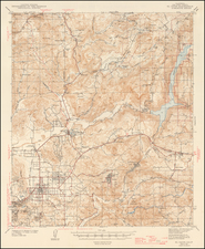
Striking early map and bird's-eye view of the lines of the Pacific Electric Railway, with an inset view of Mt. Lowe Tavern.
The map includes a number of small towns and recreational areas not often seen on printed maps. The number of rail connections stemming from Los Angeles and going in all directions is truly remarkable, especially with the route northwards from Pasadena to Mt. Lowe. The tavern here, originally called Alpine Tavern, was built in 1895 but would be destroyed by a fire in 1936, a year afte this map was made.
The Pacific Electric Railway, colloquially known as the "Red Cars," was an iconic mass transit system that operated in the Los Angeles metropolitan area from the early 20th century until its decline in the 1950s. Founded in 1901 by railroad magnate Henry Huntington and financier Isaias Hellman, the system was initially designed to promote real estate development in the sprawling Southern California landscape. At its zenith, the Pacific Electric boasted over 1,000 miles of track, connecting various neighborhoods in Los Angeles to surrounding cities like Long Beach, Pasadena, and Santa Monica. The railway played a pivotal role in shaping the urban and suburban landscapes of Los Angeles. However, with the rise of the automobile and a shift in urban planning, the system faced obsolescence and was eventually dismantled in favor of freeway development. The last Red Car ran in 1961, marking the end of an era and the beginning of Los Angeles' complicated relationship with public transportation.
The map was first produced in 1933, and bears a copyright from that date by D. W. Pontius. This example is dated from 1935 and includes a stamped note stating that service to the Mt. Lowe Tavern has been temporarily discontinued.
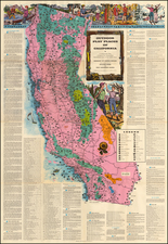
Gerald Allen Eddy moved from Michigan to Southern California in 1902.
From the 1920s, he worked in the Los Angeles area as an artist and commercial cartographer.
Eddy produced a number of pictorial and other maps of the western part of the United States. His earliest work was "Pushing Hun out of Franc eand Belgium" (1918). He produced several other war related maps during WWII, but is best known for his tourist and pictorial maps of California, Nevada and Arizona, including his "The Heart of Arizona" in 1926 and Boulder Dam map of 1931 and his iconic series of maps of Lake Tahoe.
![(California Gold Rush Artist) [Autograph Letter, from American artist William McIlvaine Jr. to artist William Thompson Russell Smith, mentioning Fronconia Notch. White Mountains]](https://storage.googleapis.com/raremaps/img/small/97179.jpg)