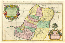
King Solomon's Holy Land, Syria, Egypt, etc.
Fascinating map of the Eastern Mediterranean by noted German mathematician, astronomer, geographer and cartographer Johann Mattias Haas, devoted to the Holy Land, Syria and Egypt during the time of Kings David and Solomon.


![(Czech Edition) Tabule a wymalovánj země Swaté [Map of the Holy Land]](https://storage.googleapis.com/raremaps/img/small/93473.jpg)
![[Title page -- Book of Martyrs] Acts and Monuments of Matters Most speciall and memorable, happening in the Church, with an universall Historie of same . . . 1632](https://storage.googleapis.com/raremaps/img/small/79484.jpg)
![[ Gonzaga Family History Dating Back to Constantinople ] Paleologi Imperatores Constantinopolitani, et Marchiones Montisferrati...](https://storage.googleapis.com/raremaps/img/small/99753.jpg)