


|
||

|

|
|

|
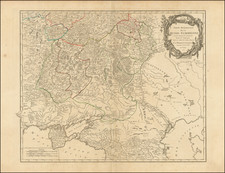
Fine old color example of this rare map depicting the theater of the Russo-Turkish War in the Ukraine in 1737.
The map provides excellent detail of the fortifications including the Ukrainian line - a system of defenses from the Dnipro to the Donetz rivers.
The Ottens brothers, Reiner and Joshua, operated a successful printing partnership in the mid-eighteenth century (fl. 1726-1765). They began the venture in 1726, publishing maps and other prints as “R & I Ottens.” They specialized in the reprinting of others’ work, especially Guillaume De L’Isle. In 1750, Reiner died; his soon, also Reiner, took his place, but the firm began listing their works as “Joshua & Reiner Ottens.” The firm lasted until Joshua’s death in 1765. Joshua’s widow, Johanna de Lindt, sold their remaining stock of plates in 1784.
![Sarmatia Utraque Europaea et Asiatica [Ancient Russia from both Europe and Asia]](https://storage.googleapis.com/raremaps/img/small/82027.jpg)
![Gibraltar to Berlin. [World War II Broadside Map.]](https://storage.googleapis.com/raremaps/img/small/83480.jpg)