|
||

|

|
|

|
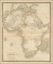
Engraved map of north Africa, showing the most up-to-date geographic knowledge available at the beginning of the 19th century.
The key notes that the map shows the following recent expeditions:
- In orange: "Mr. Park's Route in the West"
- In yellow: "Mr. Bruce's in the East"
- In red: "Route of Mr. Hornemann"
- In green: "Mr. Browne."
- In grey: grayorted by B&H."
James Rennell
James Rennell (1742-1830) was a pioneering English geographer, historian, and oceanographer. He was responsible for the first approximately accurate map of India and published the Bengal Atlas (1779). Both works were important for British colonial interests in the Subcontinent.
Rennell is best known for his survey of India, the first scientific survey of the Subcontinent ever conducted. While serving in the Royal Navy from 1756 to '63, Rennell learned the skills of an expert colonial surveyor. He accompanied Alexander Dalrymple to the Philippines in 1762. Rennell joined the East India Company in India. He served as surveyor general of Bengal (1764-77) and of BihÄr and Orissa (1767-77). He left India in 1777, returning to London where he continued to work on geographical research and publishing until his death in 1830.
![[ Eastern Hemisphere Globe Gores. ] (Nova et integra universi Orbis descriptio)](https://storage.googleapis.com/raremaps/img/small/54480.jpg)
![[Azores and Cape Verde Islands to West Africa & Spain] Barbariae et Guineae Maritimi a Freto Gibraltar ad Fluvium Gambiae cum Insulis Salsi Flandricis et Canaricis](https://storage.googleapis.com/raremaps/img/small/74954.jpg)