|
||

|

|
|

|
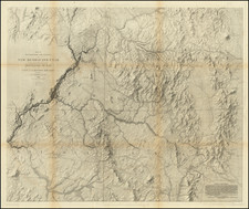
Remarkable Coast to Coast Map of Canada & The Upper Midwest & Plains
Fine example of this detailed map of Canada and the northern part of the United States, extending from the Gulf of St. Lawrence to the Pacific Ocean.
One of the few 18th Century maps of Canada to extend from the Atlantic to the Pacific. The map is of particular note for its inclusion of information from indigenous Indian Tribes, including a reference to the Indian Ochagach, one of the two most famous Indian map sources for this region.
There are numerous other Indian references ath the headwaters of Rivers, including a track extending from Ft. Huillier, just west of the modern location of Minneapolis, to the Padouca Villages on the Upper Missouri River and a number of Forts constructed by the English and French to trade with or defend against the Indians in the region.
Along the Pacific Coast, a number of real and mythical features are shown, including:
- The Land whichis supposed to be the Fou-Sang of Chinese Geographers
- Details from the apocryphal voyages of Admrial Font and Martin d'Aguilar
- The coastlines mapped by Vitus Behring and Captain Tchirikow.
- The Spanish sighting of the Sierra Nevada mountains in 1542, just north of San Francisco Bay.
The Indian Explorer Ochagach
At the headwaters of the Assinboies or St. Charles River, there is a reference to Ochagach, "Hereabouts are supposed to be the Mountain of Bright Stones mention'd in the Map of the Indian Ochagach."
The legend of Ochagach apparently began in 1728, with the report of an Indian by the name of Ochagach who described a journey to a great lake west of Lake Superior, with a river flowing from it to the west toward the sea. The noted French mapmaker Philippe Buache would ultimately report this story and create a sketch map, made by the "Savauge Ochagache" and others, which depicts a continuous water route from Lake Superior in the east, to Lac Ouimpigon (Winnepeg) and the "Fl. de l'O" (River of the West). As noted by Don McGuirk in his work on the Sea of the West, the Buache map is
. . . . important for being one of the few printed examples of manuscript Native American cartography. This second, smaller map is found above the first and is titled, "Réduction de la CARTE tracée par le Sauvage Ochagach et autres,/ laquelle a donné lieu aux Découvertes des Officiers François representées dans la Carte cy jointe."
Buache's map derives from a manuscript map and report made by French Canadian fur trader and explorer Pierre Gaultier de Varennes et de La Vérendrye (see above). In 1727, La Verendyre was the commanding officer of Fort Kaministiquia at Thunder Bay, Lake Superior. At this time, the French were actively seeking a portage or other water course which would take them to the Sea of the West or River of the West, both of which had been described and hypothesized by French explorers of the late seventeenth and early eighteenth centuries. In the winter of 1728, La Verendrye received reports from the Cree Indians of the regions to the west. One informant, a Cree Chief named Tacchigis, described a great river of the west, as well as the Missouri River Valley, persuading La Verendrye of the necessity of mounting an expedition.
In preparation for the journey, La Verendrye arranged for a Cree guide (Ochagach) to lead the expedition. Ochagach drew a map of a canoe route from Lake Superior to Lake Winnepeg, with a note referencing the River of the West at its western extremity. In the same winter, La Verendrye reported a second group of Cree Indians visiting the fort whose leader, La Marteblanche, produced a nearly identical map. La Verendrye created a composite map from these three sources which was transmitted with his report of his discoveries first to the Governor of Canada and then on to France in 1730.
Rarity
The present map is quite rare on the market in two sheets. A one sheet version, lacking the western sheet, appears more frequently. This is only the second example we have seen with both sheets present.
An important map for Canadian Collectors.
Thomas Jefferys (ca. 1719-1771) was a prolific map publisher, engraver, and cartographer based in London. His father was a cutler, but Jefferys was apprenticed to Emanuel Bowen, a prominent mapmaker and engraver. He was made free of the Merchant Taylors’ Company in 1744, although two earlier maps bearing his name have been identified.
Jefferys had several collaborators and partners throughout his career. His first atlas, The Small English Atlas, was published with Thomas Kitchin in 1748-9. Later, he worked with Robert Sayer on A General Topography of North America (1768); Sayer also published posthumous collections with Jefferys' contributions including The American Atlas, The North-American Pilot, and The West-India Atlas.
Jefferys was the Geographer to Frederick Prince of Wales and, from 1760, to King George III. Thanks especially to opportunities offered by the Seven Years' War, he is best known today for his maps of North America, and for his central place in the map trade—he not only sold maps commercially, but also imported the latest materials and had ties to several government bodies for whom he produced materials.
Upon his death in 1771, his workshop passed to his partner, William Faden, and his son, Thomas Jr. However, Jefferys had gone bankrupt in 1766 and some of his plates were bought by Robert Sayer (see above). Sayer, who had partnered in the past with Philip Overton (d. 1751), specialized in (re)publishing maps. In 1770, he partnered with John Bennett and many Jefferys maps were republished by the duo.