


|
||

|

|
|

|
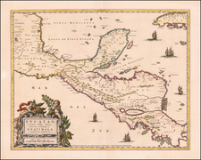
Scarce English Sea Chart Showing Eastern Central America
This chart was part of Seller and Price's English Pilot and shows the eastern coastline of Panama and the coast of Colombia, extending to Cartagena. It was published in London during a particularly pitched period of interest in the area, due to the activities of pirates and colonizers.
This chart depicts the coastline from Cartagena, Columbia west to and beyond Portobelo, Panama. There is good detail of rocks, shoals, islands, and anchorages off the shore. Rivers, bays, points, and ports are named all along the coast.
A large inset shows the bay of Portobelo, protected by two forts: Forta de la Mare and Forta Granda. Allegedly named by Christopher Columbus as porto bello, or beautiful port, the settlement served a silver-export station for the Spanish Empire. As with so many of the Spanish Caribbean settlements, the lucrative trade brought pirates to harass the town. William Parker captured the city in 1601 and the (in)famous pirate/privateer Captain Henry Morgan did so again in 1668 and John Coxon did so again in 1680. Later in the eighteenth century the port would serve as the site of large naval sieges, but at this time it was better known as a buccaneer target.
The land marked "Part of Darien", what is today Panama, would have been of most interest to the London customers for this map. In the 1690s, the Company of Scotland raised 400,000 pounds sterling, the equivalent of 47 million pounds in today's currency. The money was to start a Scottish colony in Darien, effectively a take-over of the Isthmus of Panama from nominal Spanish control. The idea was to control trade from Atlantic to Pacific across the isthmus, making Scotland rich in the process.
However sound the idea sounded in Scotland, it proved a disaster in Darien. The first expedition set out in 1698. They established a foothold on the coast called New Caledonia; it is marked on the chart. The settlers were plagued by the climate, the poor agricultural returns, the local indigenous peoples who resented the invasive presence on their land, and the lack of trade with passing ships. The colony was abandoned eight months after it started, in July of 1699. 300 of the original 1200 settlers survived.
Unfortunately, slow communication meant that a second voyage had already set out for the colony. They attempted the herculean task of building a settlement again, but this time the Spanish added to their woes. After a siege, the Scots surrendered their fort and left with their guns in 1700. The entire experiment had risen and flamed out in only three years. By 1703, when this chart was published, the survivors had crawled back to Scotland and the state was dealing with the massive financial blow. The loss was one of the reasons for the 1707 Acts of Union between England and Scotland.
The reading public would think of not only the Darien Scheme and pirate raids when they saw this map, but also the South Seas. In 1680, Bartholomew Sharpe, who had been with Henry Morgan at Portobelo in 1668, ventured to Panama with a band of buccaneers. They allied with a local indigenous leader and hiked over the isthmus. Once on the Pacific side, they stole ships and terrorized Spanish shipping with little resistance for a number of years. Accounts of their trek over the isthmus and subsequent exploits had been entertaining readers since the late 1680s, with the most famous being William Dampier's New Voyage round the World in 1697.
The mapmakers
This chart would offer a glimpse of a land most people only ever heard or read about. The swashbuckling stories of adventure associated with the region made it prescient, which is most likely why Jeremiah Seller and Charles Price released it when they did. Jeremiah Seller (1671-?) was the second son of prominent London mapmaker John Seller. He inherited two-thirds of the business upon his father's death in 1697. From 1700-5 Seller worked in partnership with Charles Price. In 1705, Jeremiah lost the family contract to supply instruments to the Royal Navy, which led to the dissolution of his partnership with Price. Seller left the map trade in that year, passing his stock to Richard Mount and Thomas Page.
Charles Price (1679?-1733) was an engraver, instrument maker, and mapseller. Price had been apprenticed to John Seller, Jeremiah's father. In fact, Jeremiah and Charles were made free of the Merchant Taylors Guild on the same day, September 1, 1703. The two were already working in partnership by then. After breaking off with Seller, Price worked with John Senex (1705-10) and George Wildey (1710-13). He was still working in the 1720s, but was in Fleet Prison in 1731 for debt and died two years later.
The chart was engraved for Seller and Price by Herman Moll (d. 1732). Moll was one of the most important London map makers in the first half of the eighteenth century. Moll was probably born in Bremen, Germany, around 1654. He moved to London to escape the Scanian Wars. His earliest work was as an engraver for Moses Pitt on the production of the English Atlas, a failed work which landed Pitt in debtor's prison. Moll also engraved for Sir Jonas Moore, Grenville Collins, John Adair, and, of course, the Seller & Price firm. He published his first original maps in the early 1680s and had set up his own shop by the 1690s.
Moll's work quickly helped him become a memberof a group which congregated at Jonathan's Coffee House at Number 20 Exchange Alley, Cornhill, where speculators met to trade stock. Moll's circle included the scientist Robert Hooke, the archaeologist William Stuckley, the authors Jonathan Swift and Daniel Defoe, and the intellectually-gifted pirates William Dampier, Woodes Rogers and William Hacke. From these contacts, Moll gained a great deal of privileged information that was included in his maps.
Over the course of his career he published dozens of geographies, atlases and histories, not to mention numerous sheet maps. His most famous works are Atlas Geographus, a monthly magazine that ran from 1708 to 1717, and The World Described (1715-54). He also frequently made maps for books, including those of Dampier's publications and Swift's Gulliver's Travels. Moll died in 1732. It is likely that his plates passed to another contemporary, Thomas Bowles, after this death.
Rarity
This is a scarce chart with few copies extant. It was part of the fourth volume of The English Pilot, a venture begun by Seller's father and then taken up by Jeremiah and Charles. This is the first state, which appeared in the 1703 edition. We are aware of only one surviving example, in the Newberry Library. There are no auction or dealer catalog records for this chart, with the exception of this example. The chart was re-issued in 1707 without the Seller & Price imprint, again with only 1 surviving example known (Boston Athenaeum) and no auction or dealer catalog records.
Charles Price (1679?-1733) was an engraver, instrument maker, and mapseller.
Price had been apprenticed to John Seller, famous mapmaker and father to Charles’ business partner, Jeremiah. In fact, Jeremiah and Charles were made free of the Merchant Taylors Guild on the same day, September 1, 1703. The two were already working together by then.
After breaking off with Seller, Price worked with John Senex (1705-10) and George Wildey (1710-13). He was still working in the 1720s, but was in Fleet Prison in 1731 for debt and died two years later.
Jeremiah Seller (1671-?) was the second son of prominent London mapmaker John Seller. He inherited two-thirds of the business upon his father’s death in 1697. From 1700-5 Seller worked in partnership with Charles Price. In 1705, Jeremiah lost the family contract to supply instruments to the Royal Navy, which led to the dissolution of his partnership with Price. Seller left the map trade in that year, passing his stock to Richard Mount and Thomas Page.


![[Central America]](https://storage.googleapis.com/raremaps/img/small/77960.jpg)