This item has been sold, but you can enter your email address to be notified if another example becomes available.


|
||

|

|
|

|
Stock# 50665
Description
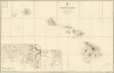
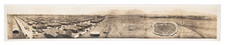
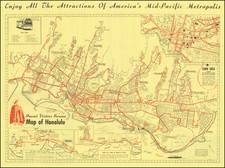
Rare separately published plan of the City of Honolulu, published for the Tourism Committee.
The map extends from Diamond Head and Kupikipikio Point to Moanalua and Kalihi Bay.
The Coral Reef is located, creating the Heavy Surf and Breakers, with Waikiki Beach prominently noted.
The map shows light rail tracks, streets, parks and other major features.
A fine example of this scarce early map of the city.
Condition Description
Folding map with original covers.
![Johnson's North America [with Inset of Hawaii]](https://storage.googleapis.com/raremaps/img/small/88883.jpg)