|
||

|

|
|

|
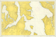
The First Official Map of Seattle
A fine example of the first official map of Seattle, prepared in conjunction with the establishment of the Seattle & Walla Walla Railroad.
The map is oriented with east at the top, with Elliott Bay at the bottom of the map and Lake Washington at the top.
The map provides a detailed grid showing Seattle's earliest neighborhoods, including Downtown, Pioneer Square, Pike Place Market, Squire Park (Central Park). Within the map, a number of early land owners, subdivisions and early claims are noted, including a list of the 7 additions to the original downtown plan, with dates that each addition was approved. Two railroad lines and a number of wharfs on Elliott Bay reflect the growth of commerce on Seattle's waterfront by 1875, although the Walla Walla line to Renton would not be completed until 1877.
The map provides an exceptional historical overview of the development of Seattle, including identifying the lands claimed by its earliest settlers, including DS Maynard and Carson Boren, although Arthur Denny's name does not appear. The "clash of grids" which resulted from the two early competing town sites is also evident on the map.
The map is preceded only by a smaller (8 x 8 inch) map issued in the Report of the Chief Engineer of the Seattle & Walla Walla Railroad and Transportation Company in 1874.
On May 16,1876, the map became the first ever "Official Map of Seattle:"
OFFICIAL MAP.
Sec. 1. Map of S. C. Harris adopted as See. 2. Ordinance in force five days after official, etc.; mayor to cause publication. park to be improved.
Ordinance No. 111.
AN ORDINANCE to provide for filing plat of and improving city property.
SECTION 1. That the map of the City of Seattle, Washington Territory, showing its additions and the " Walla Walla Railroad," drawn by S. C. Harris in 1875 and lithographed by Britton, Ray & Co., of San Francisco, California, be and the same is hereby adopted, ratified and confirmed by the City of Seattle, so far as the laying off and platting of lots seven (7), eight (8), nine (9), ten (10), eleven (11), twelve (12), thirteen (13) and fourteen (14) of section four (4); lots six (6), seven (7), eight (8) and nine (9) of section five (5); lot five (5) of section eight (8), and lots seven (7) and eight (8) of section nine (9), all in township number twenty-four (24) north, of range four (4) east of the Willamette meridian, with a park and blocks and lots; and the mayor be and he is hereby authorized and directed to cause a copy of said map, embracing said park, blocks and lots, to be duly acknowledged as a true plat, and filed for record with the auditor of King County, Washington Territory, and to cause all needed improvements to be made in, upon or about said park not to exceed the sum of five hundred dollars.
Approved May 16, 1876; published May 16, 1876.
The Robert Roblee Collection of William N. Bell family materials, circa 1850s-1910 provides an excellent early list of the original and photocopies of manuscript maps of parts of Seattle, beginning in February 1875, all of which described the earliest "Additions" to Seattle, including one listing S.C. Harris as Draftsman, but no general maps of Seattle.
S C. Harris was apparently quite active in the region. Harris also drafted the first map of Union City, which was formalized on December 6, 1870 and we note him making maps in the Skagit mining district circa 1880.
Seattle
The founding of Seattle dates back to the arrival of the Denny Party on November 13, 1851, at Alki Point. The party had traveled from the Midwest to Portland, Oregon, then up the Pacific coast into Puget Sound, with the express intent of founding a town. The following April, Arthur A. Denny abandoned the original site at Alki in favor of a better-protected site on Elliott Bay, near the south end of what is now downtown Seattle. Around the same time, Doc Maynard began settling the land immediately south of Denny's townsite. The first plats for Seattle were filed on May 23, 1853.
Nominal legal land settlement was provisionally established in 1855 (with treaty terms for what is now Seattle not implemented). Doc Maynard's land claim lay south of today's Yesler Way, encompassing most of today's Pioneer Square Historical District and the International District. He based his street grid on strict compass bearings. The more northerly plats of Arthur A. Denny and Carson D. Boren encompassed Pioneer Square north of what is now Yesler Way; the heart of the current downtown; and the western slope of First Hill. These had street grids that more or less followed the shoreline. The downtown grid from Yesler Way north to Stewart Street is oriented 32 degrees west of north; from Stewart north to Denny Way the orientation is 49 degrees west of north. The result is a tangle of streets where the grids clash.
Seattle and Alki would grow as competing cities, although in the early days, there were less than 8 blocks of flat usable land in Seattle. However, the arrival of Henry Yesler and his establishment of a lumber mill between the Denny and Maynard grids established Seattle as the primary hub in the area.
The town would grow slowly for the next 20 years. On July 14, 1873, the Northern Pacific Railway selected Tacoma over Seattle as the Western terminus of their transcontinental railroad. The railroad barons appear to have been gambling on the advantage they could gain from being able to buy up the land around their terminus cheaply instead of bringing the railroad into a more established Pacific port town.
The citizens of Seattle chartered their own railroad, the Seattle & Walla Walla, to link with the Union Pacific Railroad in eastern Washington. The S&WW never got beyond Renton, but that was far enough to connect with new coal mines, fueling industry in Seattle.
Rarity:
The map is extremely rare. OCLC locates only an electronic record at the Seattle Public Library for the map.
![Johnson's Washington Oregon and Idaho [Massive Dakota Territory]](https://storage.googleapis.com/raremaps/img/small/98348.jpg)