


|
||

|

|
|

|
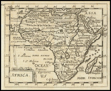
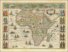
Rare first state of Willem Janszoon Blaeu's map of Africa.
A cornerstone map of Africa in its first state by Blaeu (bearing his original latinized name Guillaume Janssonius), published as part of a set of the continents, and being reductions of his own wall maps of 1608.
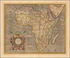
With the decorative three border panels including views of Alexandria, Algier, Cairo, Ceuta, Tangier, Tunis, the Canarian island and Mozambique, and the mine at St. George in Guinea.
This map was issued until Blaeu's name was changed in 1621.
The body of the map is richly embellished with animals, including elephants, monkeys, ostriches, gazelles, lions, cheetahs and camels. In the oceans are numerous sailing ships, sea monsters, flying fish, and a goregous compass rose.
This first state is extremely rare. This is the first example we have ever seen on the market.
Willem Janszoon Blaeu (1571-1638) was a prominent Dutch geographer and publisher. Born the son of a herring merchant, Blaeu chose not fish but mathematics and astronomy for his focus. He studied with the famous Danish astronomer Tycho Brahe, with whom he honed his instrument and globe making skills. Blaeu set up shop in Amsterdam, where he sold instruments and globes, published maps, and edited the works of intellectuals like Descartes and Hugo Grotius. In 1635, he released his atlas, Theatrum Orbis Terrarum, sive, Atlas novus.
Willem died in 1638. He had two sons, Cornelis (1610-1648) and Joan (1596-1673). Joan trained as a lawyer, but joined his father’s business rather than practice. After his father’s death, the brothers took over their father’s shop and Joan took on his work as hydrographer to the Dutch East India Company. Later in life, Joan would modify and greatly expand his father’s Atlas novus, eventually releasing his masterpiece, the Atlas maior, between 1662 and 1672.