|
||

|

|
|

|
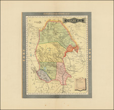
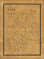
Beautifully artistic seventeenth-century map showing the lands of a prominent Tlaxcala noble family
This exquisitely colored map shows the lands of Doña Francisca Maxixcatzin and that of fellow landowner Pablo Juarez. A rosy sunset glows over a mountain range on the west-oriented document. At the foot of the mountains is the Hacienda Jacomebela and the church of Santa Inez. The lands of Doña Maxixcatzin surround the cerros, or hills, where the churches of Santa Marta Justine and Santa Anna Chicaulta are shown in great detail and brilliant color. The lands in the foreground belong to Pablo Juarez.
According to the explanation at the bottom of the page, this map was made at the request of Doña Francisca and the cabildo, or city council, of a nearby town. The map is to be kept especially by Luiz Pimintel Maxixcatzin and is meant to remind all involved precisely who owns which parcels of land.
Francisca Maxixcatzin was a wealthy landowner and wife of a colonial governor in sixteenth-century New Spain. Doña Francisca was the final heir in the line of the kings of Ocotelolco, an indigenous noble family. Ocotelolco was one of four independent altepetl, or polities, that made up the confederation of Tlaxcallan. It was the ruler Maxixcatzin who controlled Ocotelolco when the Spanish came. Over a century later, Doña Francisca seems to be the last of her family.
Doña Francisca married Don Diego Muñoz Camargo García Vázquez, who served as the governor of Tlaxcala from 1608 to 1612. Muñoz's father, another Diego Muñoz Camargo, was a famous Tlaxcalan historian and was himself the son of a conquistador Spaniard and an indigenous woman.
Doña Francisca inherited lands from her husband, who had died by 1628, and was involved in several land transfers during her adulthood. She was mentioned by the Nahua noble, Tlaxcala city council ( cabildo) member, and annalist Don Juan Buenaventura Zapata y Mendoza and it is most likely the Tlaxcala cabildo who, along with Doña Francisca, requested this map be made.
Luiz Pimintel Maxixcatzin was Doña Francisca's son. On January 1, 1627, he was appointed alcalde ordinario, a city official of Tlaxcala. He married Mariana Pimintel in 1634.
Full title:
Mapa de las tierras de Doña Fransisca Maxixcatzin que estan en Sta. Anna chiautla Sta. Ynez, Sta. Marta y tambien en las tierras de Pablo Juares se yso para que lo tengan y guarden y que no les falte tomo possession dn. Luiz Pimintel Maxixcatzin se yso esta Mapa a pedimento de Doña Fransisca Maxixcatzin y de los Señores del cabildo y se puso el largo, y ancho de las tierras y tambien las d Pablo Juares para que Sepan que es Sulla la escritura y donacion del Mapa o papel que se iso a cuatro dias del mes de Agosto del año del Señor de Mill Seis Cientos y Cuarenta y uno a &c. ante mi Francisco Gainos (signature)
Camila Townsend, “Don Juan Buenaventura Zapata y Mendoza and the Notion of a Nahua Identity,” The Conquest All Over Again: Nahuas and Zapotecs Thinking, Writing, and Painting Spanish Colonialism, ed. Susan Schroeder (Brighton: Sussex Academic Press, 2010), 168.
Tlaxcala cabildo document mentioning Luis Pimintel Maxixcatzin, https://vistas.ace.fordham.edu/themes/political-texts/tlaxcala-council/
![(Texas - Apache Depredations in Mexico) Discurso Que Pronunció el señor Coronel D. José Joaquin Calvo, Comandante general del Estado de Chihuahua, al entrar en ejercicio del Supremo Poder Ejecutivo del mismo [caption title]](https://storage.googleapis.com/raremaps/img/small/93111.jpg)