![(Mercator-Hondius Asia) A Leaf from the Mercator-Hondius World Atlas Edition of 1619 with an Essay by Norman J. W. Thrower [with map:] Asia ex magna orbis terre description Gerardi Mercatoris desumpta studio et industria G.M. Iunioris. By Norman J. W. Thrower / Gerard Mercator / Jodocus Hondius](https://storage.googleapis.com/raremaps/img/small/101528.jpg)


|
||

|

|
|

|
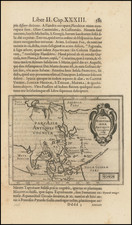
Rare separately published example of Mercator's map of Asia, with no text on the verso. The map includes an ornate cartouche trumpeting Mercator's authorship and a ship in full sail to the northeast of Japan.
Korea is not shown, while the islands of Southeast Asia are jumbled together. The viewer's eye is drawn to the large, open space of Java Maior. The name comes from the writings of Marco Polo who, following twelfth-century Arabic usage, called Java, Java Major, and Sumatra, Java Minor. Mercator did not adopt the use of Java Minor for Sumatra, instead placing the island of Minor to the south in his 1569 world map, next to a large southern continent which bears the Polo-inspired place names of Beach, Lucach, and Maletur. This continent is referenced on Mercator's Asia map as Terrae, which just peeps out of the border of the map. Australis Pars, or part of Australia, is also included in the southeast corner of the map.
A narrow strait, labeled Anian, separates America and Asia in the northeastern portion of the map. This geographic feature also gained its name from Marco Polo, who mentioned the Chinese province of Ania in his writings. Mercator and his contemporaries like Giacomo Gastaldi and Abraham Ortelius all depicted a strait separating Asia and America from the early 1560s onward. Although mapmakers from the sixteenth to the eighteenth century would move such a strait up and down the western coast on North America, it was finally delineated in the mid-eighteenth century and we know it today as the Bering Strait.
As previously mentioned, the Asia map is derived from Mercator's famous world map of 1569, Nova et Aucta Orbis Terrae Descriptio ad Usum Navigantium Emendate Accommodata (A new and more complete representation of the terrestrial globe properly adapted for use in navigation). This map retains its standing in the history of cartography because it was the first to place latitude and longitude at right angles to each other, greatly increasing the efficacy of the chart for calculating sailing routes. The trade-off of the projection, however, is the severe distortion of land masses in extreme high latitudes.
Mercator was born in Flanders in 1512. His parents died when Gerard was a teenager and his education was left in the hands of his great-uncle, a priest. After graduating from the University of Louvain in 1532, Mercator studied geography under Gemma Frisius and engraving under Gaspar Van der Heyden. The trio made maps and instruments together. Mercator spent time in prison at the hands of the Inquisition in 1544 under suspicion of heresy for his beliefs about the creation of the earth. He was later released. In 1552, Mercator moved to Duisburg, Germany and built his map business there. In the 1580s and early 1590s, Mercator published two map collections which he compiled and his sons and grandsons engraved. He died in 1594. His son, Rumold, published his father's collected maps in 1595 with the title, Atlas Sive Cosmographicae Meditationes de Fabrica Mundi et Fabricati Figura. This was the first use of 'atlas' to refer to a book of maps. The Asia map was included in the Atlas Sive Cosmographicae, but this is a rarer, separately published edition.

![[6 Sheet Wall Map of Asia] L'Asie divisee suivant l'Estendue de ses Principales Parties dans lesquelles sont distinguees les unes de autres Les Empires, Monarchies, Estats et Principaux Peuples qui partagent a present L'Asie . . . 1719](https://storage.googleapis.com/raremaps/img/small/80841.jpg)

![[ Dalai Lama ] Grand Lama](https://storage.googleapis.com/raremaps/img/small/97873.jpg)