- Antique Maps
- Europe
- British Isles
- Les Isles Britanniques Comprenant les Royaumes...
Map Maker
Title
Les Isles Britanniques Comprenant les Royaumes D'Angleterre D'Ecosse et D'Irlande, Divises en Grandes Provinces Subdivise par Comptes . . . 1791
Publication Place / Date
Paris / 1791
Image Dimensions
25.5 x 18.5 inches
Color
Hand Colored
Condition
VG+
Stock# 48880
$ 295.00
Map Maker
Authenticity Guarantee
All of our maps are authentic antique maps, printed or drawn on or about the date shown in the description. In rare instances when we offer facsimiles, we will specifically describe the map as a later facsimile and include the date of publication. Certificates of Authenticity are included with each item.
Map Maker
Fast, Global Shipping
Last year we shipped over 4,500 antique maps to more than 50 countries. Maps are shipped Monday through Friday year-round. If an order is received before 2 PM PST, we will ship the order that day. If an order is received after that time, we will ship the next day. We ship maps either flat in custom packages or in specially ordered thick tubes. Shipping rates are provided as part of the checkout process.
Description
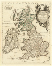
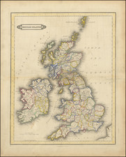
Fine large format map of the British Isles, with a large inset of the Orkades and Shetlands.
The map includes a fine ornate cartouche and coat of arms, with the various countries colored by regions and counties.
This large format Janvier map is quite scarce on the market.
Related Categories
Related Items