


|
||

|

|
|

|
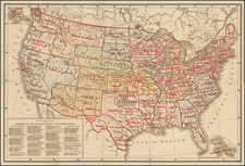
Fine old color example of William Faden's map of the United States.
Scarce early map of the United States by William Faden, published in London in 1785.
A nice old color example of State 4 of Faden's map of the United States, one of the first and finest English maps to display the boundaries of the newly recognized United States. Faden published the map (originally titled The British Colonies in North America) in 1777 during the Revolutionary War, and regularly revised and updated it as new information became available. This is the fourth state of the map and the third to include the name "United States."
Faden's sequence of maps of the United States represents one of the most important cartographic depictions of the newly independent republic. The Faden sequence is perhaps the most comprehensive series of maps to illustrate the political development of the United States, with each variant state showing a distinct stage in America's process of transformative change. The present map depicts the United States with its new boundaries as determined at the end of the Revolutionary War, as ratified at the Treaty of Paris, signed on September 3rd, 1783. The map is beautifully colored to identify American, British, Spanish territories, and the coasts of Newfoundland, rich in cod then, to which the French were granted fishing rights.
The following are some noteworthy changes in this state of the map:
- The addition of Vermont
- The removal of "Province of Quebec" from the region extending to the Ohio River
- Lake Erie and Lake Ontario are substantially revised
- The geography below Lake Erie is updated
- The Twenty Leagues Line has been added off the coast of the United States, defining its territorial waters
- The dispute regarding the location of the St. Croix River is described in the text
- The Maine-Canada border is significantly revised
The map includes open western borders for every state from Georgia to Pennsylvania, except South Carolina, referencing the original colonial claims for Pennsylvania, Virginia, North Carolina, and Georgia, all of which were to run to the Pacific Ocean. The boundaries between New York, the Iroquois Nation and Pennsylvania, are non-existent. Vermont is shown as a state for the first time. New Hampshire is shown.
The map covers an area from Newfoundland and James Bay to the southern tip of Texas, here labeled "Cenis" for the Indian tribe that occupied the eastern region. The United States is rendered in solid yellow, while other political entities are indicated by colored outline. Faden distinguishes between the British territories of today's Canada and the Bahamas and the Spanish territories of Louisiana and Florida.
Beginning in Louisiana Territory, Arkansas is named, but no reference to New Iberia or the Fair Nation, which appear in later editions. Many Indian tribal names appear and a large stretch of land north of the Missouri River is identified as "Extensive Meadows full of Buffaloe."
This map pre-dates Faden's depictions of the various company lands given to Soldiers and proprietors shortly after the conclusion of the War, which later exist in the west, including New Jersey Company, Wabash Company, the Army Lands, the Lands reserved for the Carolina Troops, Colonel Simms, Donation Lands, Seven Ranges, Virginia Troops, etc.
Georgia runs to the Mississippi, with lots of Indian tribes and East and West Florida shown. One early road appears in Texas.
The map went through a number of variant states, many of which are quite interesting. Ashley Baynton Williams identifies 8 states of the map.
The 1st state of the map is entitled The British Colonies in North America and was published in 1777.
The 2nd state of the map shows 2 different Rivers named "St Croix" flowing into the Bay of Fundy.
The 3rd state of the map adds an annotation below the color key stating that the source of the River St. Croix has not been truly ascertained and only 1 of the 2 rivers is now named St. Croix.
The 4th state adds the words "of 1784" after "according to the Treaty," and is dated 1785.
The 5th state is dated 1793 and the title is revised to read ". . . British Territories, and Those of Spain . . ."
The 6th edition adds a notation to the color key that all lands not settled by Europeans "should belong by right to the Aborigines." The 6th state is also the first to name the "Tannesse Government" and to show the new national capital, "Washington or / the Federal City." The map is also one of the few maps to record the short-lived state of "Franklinia." Franklinia was formed by settlers in 1784, but it was never recognized by Congress. Eventually it was annexed by North Carolina and later reverted back to Tennessee.
The 7th edition of the map is now dated 1796.
The 8th edition of the map is dated 1809 and the title is shortened, removing the words "according to the Treaty, of 1784."
William Faden (1749-1836) was the most prominent London mapmaker and publisher of the late-eighteenth and early-nineteenth centuries. His father, William Mackfaden, was a printer who dropped the first part of his last name due to the Jacobite rising of 1745.
Apprenticed to an engraver in the Clothworkers' Company, he was made free of the Company in August of 1771. He entered into a partnership with the family of Thomas Jeffreys, a prolific and well-respected mapmaker who had recently died in 1771. This partnership lasted until 1776.
Also in 1776, Faden joined the Society of Civil Engineers, which later changed its name to the Smeatonian Society of Civil Engineers. The Smeatonians operated as an elite, yet practical, dining club and his membership led Faden to several engineering publications, including canal plans and plans of other new engineering projects.
Faden's star rose during the American Revolution, when he produced popular maps and atlases focused on the American colonies and the battles that raged within them. In 1783, just as the war ended, Faden inherited his father's estate, allowing him to fully control his business and expand it; in the same year he gained the title "Geographer in Ordinary to his Majesty."
Faden also commanded a large stock of British county maps, which made him attractive as a partner to the Ordnance Survey; he published the first Ordnance map in 1801, a map of Kent. The Admiralty also admired his work and acquired some of his plates which were re-issued as official naval charts.
Faden was renowned for his ingenuity as well as his business acumen. In 1796 he was awarded a gold medal by the Society of Arts. With his brother-in-law, the astronomer and painter John Russell, he created the first extant lunar globe.
After retiring in 1823 the lucrative business passed to James Wyld, a former apprentice. He died in Shepperton in 1826, leaving a large estate.
![[United States]](https://storage.googleapis.com/raremaps/img/small/93852.jpg)
![[ Catholic Dioceses and Missions in the United States ] Karte der katholischen Dioecesen und der en Missionen in Nordamerika nach den nuesten geographischen Angaben... 1845](https://storage.googleapis.com/raremaps/img/small/98630.jpg)