


|
||

|

|
|

|
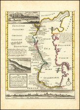
Herman Moll's map provides a detailed portrayal of the Caspian Sea region. This map is based on the groundwork of Carl van Verden, a Dutch seaman in the employ of the Russian Navy, who created one of the most precise maps of the Caspian Sea at the time.
The map by Moll features a range of valuable geographic information, including several cities' inset views. Among these are the "City of Astracan" shown across the bottom of the map, the "City of Terky" depicted in the upper left corner, and the "City of Derbent" presented above the title cartouche.
Astrakhan, located at the northernmost part of the Caspian Sea, was a significant city in the Volga Delta due to its strategic position for trade routes and fisheries. Terki, now known as Makhachkala, is the capital of the Republic of Dagestan, Russia. In the early 18th century, it was a fortress and a critical location for controlling the trade route from the Caucasus to the Caspian Sea. Derbent, one of the oldest inhabited cities in the world, lies in the Republic of Dagestan and served as a vital checkpoint along the north-south passage between the Caspian Sea and the Caucasus Mountains.
The map also includes the naming of various coastal towns along the western coast of the Caspian Sea. This attention to detail reflects the meticulousness of van Verden's original survey, which provided an in-depth perspective of the Caspian Sea's geographic complexity.
Van Verden's work on mapping the Caspian Sea was significant because it directly preceded and likely influenced Peter the Great's 1722 invasion of Baku and Derbent and consequently established Russian hegemony in the region. Despite the importance of his work, Van Verden was later overlooked by the Czar, favoring Vitus Behring for the commission to discover a Northeast Passage through the Russian Arctic.
Herman Moll (c. 1654-1732) was one of the most important London mapmakers in the first half of the eighteenth century. Moll was probably born in Bremen, Germany, around 1654. He moved to London to escape the Scanian Wars. His earliest work was as an engraver for Moses Pitt on the production of the English Atlas, a failed work which landed Pitt in debtor's prison. Moll also engraved for Sir Jonas Moore, Grenville Collins, John Adair, and the Seller & Price firm. He published his first original maps in the early 1680s and had set up his own shop by the 1690s.
Moll's work quickly helped him become a member of a group which congregated at Jonathan's Coffee House at Number 20 Exchange Alley, Cornhill, where speculators met to trade stock. Moll's circle included the scientist Robert Hooke, the archaeologist William Stuckley, the authors Jonathan Swift and Daniel Defoe, and the intellectually-gifted pirates William Dampier, Woodes Rogers and William Hacke. From these contacts, Moll gained a great deal of privileged information that was included in his maps.
Over the course of his career, he published dozens of geographies, atlases, and histories, not to mention numerous sheet maps. His most famous works are Atlas Geographus, a monthly magazine that ran from 1708 to 1717, and The World Described (1715-54). He also frequently made maps for books, including those of Dampier’s publications and Swift’s Gulliver’s Travels. Moll died in 1732. It is likely that his plates passed to another contemporary, Thomas Bowles, after this death.
![The Turkish Empire in Asia [shows Cyprus]](https://storage.googleapis.com/raremaps/img/small/37050.jpg)