|
||

|

|
|

|
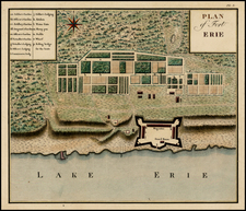
Rare British Admiralty Chart of the Niagara River from Buffalo to Lake Ontario.
Finely detailed chart the Niagara River, extending from Lake Erie, Fort Erie and the newly established Buffaloe Town on Buffalo Creek, based upon a survey of the River taken in 1817 by William FitzWilliam Owen.
Surveyed after the conclusion of the War of 1812, the map identifies property owners, mills, dozens of places, soundings, roads, etc. The ruins are Fort Schlosser are shown near Goat Island.
Shortly before the survey, in 1815, the State of New York had purchased Grand Island and other small islands in the Niagara River from the Iroquois nation for $1,000 in hand, and annually, forever, a perpetuity of $500 (to this day, paid every June). The treaty was signed by Governor Daniel D. Tompkins, Peter B. Porter, Chief Red Jacket, Falling Boards, Twenty Canoes, Sharp Shins, Man Killer, and others. The Senecas reserved the right to hunt, fish and fowl on the islands.
William FitzWilliam Owen
Vice Admiral William Fitzwilliam Owen (1774 - 1857), was a British naval officer and explorer. He is best known for his exploration of the west and east African coasts, discovery of the Seaflower Channel off the coast of Sumatra and for surveying the Canadian Great Lakes.
The illegitimate son of Captain William Owen he was orphaned at the age of four, but his father's friend Rear-Admiral Sir Thomas Rich, kept an eye on both William and his elder brother Edward, in 1788, at age 13 he embarked as a midshipman in Rich's ship, HMS Culloden, and from that time the Royal Navy was his life.
He served at home and on ships in the East Indies. He was commissioned as a lieutenant in 1797. In 1801 he took command of the fireship HMS Nancy. After the resumption of war with France in 1803, Owen was given command of the 16-gun brig HMS Seaflower, which sailed to the East Indies. There he served under Rear-Admiral Sir Edward Pellew, Commander-in-Chief East Indies.
He explored the Maldive Islands in 1806, and in the same year discovered the Seaflower Channel, between the islands of Siberut and Sipora off the west coast of Sumatra.
He fought the Dutch in the East Indies, but September 28, 1808, the French frigate Manche captured Seaflower. The French held Owen from 1808 to 1810 in Mauritius, during which time he was promoted to commander. After his release Owen was promoted to post captain in May 1811, before returning to England in 1813.
Owen's first appointment specifically as a surveyor was to duty in the Canadas from May 1815 to August 1817. During his time in Canada, he undertook two major projects, the first was a rapid reconnaissance in the summer of 1815 to determine a number of urgently needed facts, followed by deliberate scientific surveying of the St Lawrence River and the Great Lakes. While crossing the Atlantic he began an "astronomical journal" which eventually contained the longitude and latitude of significant locations along the Canadian waterway from Quebec City to Penetanguishene on Georgian Bay. These fixed points set the general frame of the surveying that followed.
During his first summer in Upper Canada, Owen confirmed the survey work already under way on Lake Ontario and the Grand River and examined both the mouth of the latter and the bay within Turkey Point in search of an appropriate site for a naval base. The international boundary at Saint-Régis near Cornwall was located, and extensive soundings were taken in the Detroit River, in order to provide data about the several channels which would be used in establishing the international boundary there. In addition to running the survey of the north shore of Lake Erie, Owen began another of the east shore of Lake Huron and of Georgian Bay to near present-day Victoria Harbor. In this second survey, land forms, timber resources, and navigational hazards were observed and again the site for a naval base was sought. A hinderance to the work arose from the heated tensions between British and Americans on the Detroit frontier. Lieutenant Alexander Thomas Emeric Vidal, a principal surveying officer under Owen, was arrested and detained at Detroit, which gave rise to time-consuming negotiations and protracted correspondence between British and American authorities.
Owen was next ordered to conduct a systematic survey of the St Lawrence River and lower Great Lakes on November 5, 1815, envisaging work first in the region close to Kingston, and then in the upper lakes, and if time permited the frontier waters of Lake Champlain. The survey began on February 1, 1816,with Captain Owen leading a group of 7 officers and some 50 seamen and marines out onto the ice about the Thousand Islands to measure survey baselines. In the following 69 days, about 300 miles of baseline were surveyed in an area 80 by 30 miles, with some 10,000 angles and bearings being recorded. Owen believed the accuracy could not "err two inches in a mile."
This episode, the beginning of accurate naval surveying in Canada, was typical of Owen, and his report breathes energy: in weather that reached -20°F, work took place "every day successively except the Sabbath from Eight O'Clock in the morning to six at night." Yet there were special pay, extra clothing, and double rum rations for the men. Thus a formidable surveying problem was solved while the naval garrison was relieved from the tedium of winter routine.
A stone house in Kingston became the hydrographic office, supplying quarters for the officers of the survey, facilities for projecting their work, and a place for consultation and instruction. Through the spring and summer of 1816 the surveying progressed until Lake Ontario and the St Lawrence River to near Prescott were completed. Early in 1817 the Niagara River was surveyed. On 14 June, Lake Erie lay before the surveyors when the establishment was closed down as a matter of peace-time economy. Lieutenant Henry Wolsey Bayfield, who had first learned surveying on the ice in February 1816 under Owen's instruction, was left to complete the work when Owen returned to England in June 1817.
Captain Owen had also borne the considerable weight of day-by-day naval administration from 26 Oct. 1815 to 31 May 1816 when he was the senior naval officer on the Canadian lakes in the absence of both the commander-in-chief and the navy commissioner. Beyond administrative detail and the direction of surveying, he continued to deal with the overriding problems of strategic planning. He reported at length on the siting of naval bases above Niagara and lines of communication which would be secure in time of war. Surveying the western shores of Lake Ontario and the Grand River led to speculation about a route from Burlington Bay (Hamilton Harbour) to the Grand River and Lake Erie. He also reported at length on possible improvements in the established route between York (Toronto) and Lake Huron by way of the Nottawasaga River. In May and early June 1817 he traversed the Trent-Severn water route with a small party and Indian guides but found it less practicable because of the need for expensive works. He had laboured with great energy and insight and his findings helped in the understanding of numerous key geographical situations which had been unclear until that time. The 27 months of Canadian service had established him as a master of surveying and his work founded scientific hydrography in Canada.
Owen mapped the entire east African coast from the Cape to the Horn of Africa between 1821 and 1826 in the sloop Leven and in company with the brig Barracouta. During this period, Owen established a one man protectorate of Mombasa with the aim of disrupting the 'hellish trade' in slaves. Owen was later forced to shut down under orders from the Crown after only three years. When he returned in 1826, with 300 new charts, covering some 30,000 miles of coastline, over half of his original crew had been killed by tropical diseases.
In 1827 he was in charge of settling a colony at Fernando Po. During the first year, he was joined by Lieutenant James Holman who was famous in his time as "the Blind Traveller".
In the mid-1830s, having little hope of further naval appointment, he removed with his family to New Brunswick. He secured title to Campobello Island, which had been granted to his grandfather and was lord proprietor of the same as well being involved in other investments in New Brunswick. From 1841 he served as a justice of the peace as well as concurrently as judge of the Inferior Court of Common Pleas.
Between 1837 and 1842 he was a very visible member of the New Brunswick House of Assembly for Charlotte County. Following his defeat for reelection, he was appointed in December 1843 to the New Brunswick Legislative Council of which he was an active member through 1851.
In the final action of his naval career, between September 1842 and December 1847, he conducted the definitive survey of the Bay of Fundy for the Admiralty. Indeed some charts of the area are still based upon his surveys.
The British Admiralty has produced nautical charts since 1795 under the auspices of the United Kingdom Hydrographic Office (HO). Its main task was to provide the Royal Navy with navigational products and service, but since 1821 it has also sold charts to the public.
In 1795, King George III appointed Alexander Dalrymple, a pedantic geographer, to consolidate, catalogue, and improve the Royal Navy’s charts. He produced the first chart as the Hydrographer to the Admiralty in 1802. Dalrymple, known for his sticky personality, served until his death in 1808, when he was succeeded by Captain Thomas Hurd. The HO has been run by naval officers ever since.
Hurd professionalized the office and increased its efficiency. He was succeeded by the Arctic explorer Captain William Parry in 1823. By 1825, the HO was offering over seven hundred charts and views for sale. Under Parry, the HO also began to participate in exploratory expeditions. The first was a joint French-Spanish-British trip to the South Atlantic, a voyage organized in part by the Royal Society of London.
In 1829, Rear-Admiral Sir Francis Beaufort was appointed Hydrographer Royal. Under his management, the HO introduced the wind force scale named for him, as well as began issuing official tide tables (1833). It was under Beaufort that HMS Beagle completed several surveying missions, including its most famous voyage commanded by Captain FitzRoy with Charles Darwin onboard. When Beaufort retired in 1855, the HO had nearly two thousand charts in its catalog.
Later in the nineteenth century, the HO supported the Challenger expedition, which is credited with helping to found the discipline of oceanography. The HO participated in the International Meridian Conference which decided on the Greenwich Meridian as the Prime Meridian. Regulation and standardization of oceanic and navigational measures continued into the twentieth century, with the HO participating at the first International Hydrographic Organization meeting in 1921.
During World War II, the HO chart making facility moved to Taunton, the first purpose-built building it ever inhabited. In 1953, the first purpose-built survey ship went to sea, the HMS Vidal. Today, there is an entire class of survey vessels that make up the Royal Navy’s Hydrographic Squadron. The HO began to computerize their charts in the late 1960s and early 1970s. In 1968, the compilation staff also came to Taunton, and the HO continues to work from there today.
![[Lake Champlain and environs] Carte de la Riviere de Richelieu et du Lac Champlain](https://storage.googleapis.com/raremaps/img/small/91308.jpg)
![Amer. Sep. No. 19 & 20 [Partie du Groenland and Groenland Orientale]](https://storage.googleapis.com/raremaps/img/small/19107.jpg)