|
||

|

|
|

|
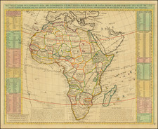
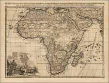
Rare separately published map of Africa by Robert Sayer.
While the map appears relatively unimposing, this was in fact the map utilized by the successors to John Spilsbury (1739-1769) for the earliest jigsaw puzzle map of Africa.
Spilsbury produced a World map puzzle and puzzles of the four continents together with puzzles of England, Wales, Ireland, and Scotland. The maps were designed as teaching aids for geography classes. As pupils put the pieces together, they would learn how different countries connected to one another.
Upon Spilsbury's death in 1769 the business was continued by his widow Sarah May, who would later marry her husband's former apprentice Harry Ashby. Not soon after the marriage Ashby brought in the map and printseller's Woodman and Mutlow to run part of the business.
The present map is the original uncut map sheet. makers of the puzzle, Woodman and Mutlow, placed their label over Robert Sayer's name, before dissecting the map.
Robert Sayer (ca. 1724-1794) was a prominent London map publisher. Robert’s father was a lawyer, but his older brother married Mary Overton, the widow of prominent mapmaker Philip Overton and the proprietor of his shop after his death. Mary continued the business for roughly a year after her marriage and then, in early 1748, it passed to Robert. Robert became a freeman of the Stationers’ Company later that year; his first advertisement as an independent publisher was released in December.
Sayer benefited from Overton’s considerable stock, which included the plates of John Senex. In the 1750s, Sayer specialized in design books and topographical prints, as well as comic mezzotints. In 1753, he, along with John Roque, published a new edition of Thomas Read’s Small British Atlas, the first of several county atlases that Sayer would publish.
Sayer’s business continued to grow. In 1760 he moved further down Fleet Street to larger premises at 53 Fleet Street. In 1766, he acquired Thomas Jefferys’ stock when the latter went bankrupt. In 1774, he entered into a partnership with John Bennett, his former apprentice. The pair specialized in American atlases, based on the work of Jefferys. They also began publishing navigational charts in the 1780s and quickly became the largest supplier of British charts in the trade.
Bennett’s mental health declined, and the partnership ended in 1784. As Sayer aged, he relied on his employees Robert Laurie and James Whittle, who eventually succeeded him. He spent more and more time at his house in Richmond. In 1794, he died in Bath.