|
||

|

|
|

|
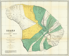
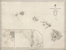
Rare Sea Chart Showing Pearl Harbor, Published in The Same Month As the Creation of the Pearl Harbor Naval Station
Rare separate issued chart of the Hawaiian Islands, published by the US Coast & Geodetic Survey in 1898, with revisions to November 1899.
The present chart is notable for its inclusion of a large format plan of "Pearl River and Lochs," showing Pearl Harbor in its infancy, along with an inset plan of Honolulu. At the time of the chart's creation, Pearl Harbor was still too shallow for significant navigation and prior to its initial fortification by the United States.
Pearl Harbor
Pearl Harbor was originally an extensive shallow embayment called Wai Momi (meaning, "Waters of Pearl") or Puʻuloa (meaning, "long hill") by the Hawaiians. Puʻuloa was regarded as the home of the shark goddess, Kaʻahupahau, and her brother (or son), Kahiʻuka, in Hawaiian legends.
During the early 19th century, Pearl Harbor was not used for large ships due to its shallow entrance.
When King Lunalilo died in 1873, negotiations were underway for the cessation of Pearl Harbor as a port for the duty-free export of sugar to the U.S. With the election of King Kalākaua in March 1874, riots prompted landing of sailors from USS Tuscarora and Portsmouth. The British warship, HMS Tenedos, also landed a token force. During the reign of King Kalākaua, the United States was granted exclusive rights to enter Pearl Harbor and to establish "a coaling and repair station."
Although this treaty continued in force until August 1898, the U.S. did not fortify Pearl Harbor as a naval base. The shallow entrance constituted a formidable barrier against the use of the deep protected waters of the inner harbor as it had for 60 years.
The United States and the Hawaiian Kingdom signed the Reciprocity Treaty of 1875 as supplemented by Convention on December 6, 1884. The Reciprocity Treaty was made by James Carter and ratified it in 1887. On January 20, 1887, the United States Senate allowed the Navy exclusive right to maintain a coaling and repair station at Pearl Harbor. The US took possession on November 9, 1887. Following the overthrow of the Hawaiian Kingdom, the United States Navy established a base on the island in 1899.
In May 1899, Commander John F. Merry was made naval representative with authority to transact business for the Navy Department and its Bureaus. He immediately assumed control of the Coal Depot and its equipment. To supplement his facilities, he was assigned the Navy tug Iroquois and two coal barges. Inquiries that commenced in June culminated in the establishment of the "Naval Station, Honolulu" on November 17,1899. On February 2, 1900, this title was changed to "Naval Station, Hawaii".
The chart is extremely rare. OCLC locates an example of the 1898 chart, but not this 1899 variant edition. We locate no other examples offered for sale at auction or in dealer catalogs.