|
||

|

|
|

|
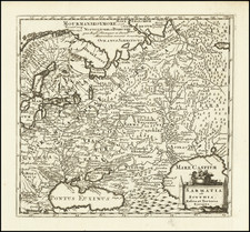
Fine map of the Northwestern part of North America, illustrating the compilation of cartographic information by Joseph Nicholas De L'Isle, following his return from the Russian Academy in St. Petersburg.
The map's title is a direct translation from De L'Isle's Carte Generale des Découvertes de l'Amiral de Fonte . . . , first published in September 1752. While first issued circa 1761, the map was also included in Jefferys very rare General topography of North America and the West Indies: . . .printed for Robert Sayer ... and Thomas Jefferys, 1768.
The present map shows a number of the great myths regarding the Northwest Coast of America, interspersed with facts. Highlights include:
- West Sea Discovered by De Fuca 1592 (The Sea of the West)
- Entrance discovered by De Fuca
- Entrance discovered by Juan Aguilar in 1603
- Ths Discoveries of 1722 and 1728 along the Northwest Coast of America
- Admiral De Fonte's discoveries in 1640
- L.(ake) De Font or Mishinipi
- Lake in which Bernarda sailed 436 Leagues
- Land seen by Chirikow in 1741
The mulitple waterways depicted on the map which connect the northwest coast of America with Hudson's Bay and the Arctic Sea are of great interest.
A rare and interesting map.
Thomas Jefferys (ca. 1719-1771) was a prolific map publisher, engraver, and cartographer based in London. His father was a cutler, but Jefferys was apprenticed to Emanuel Bowen, a prominent mapmaker and engraver. He was made free of the Merchant Taylors’ Company in 1744, although two earlier maps bearing his name have been identified.
Jefferys had several collaborators and partners throughout his career. His first atlas, The Small English Atlas, was published with Thomas Kitchin in 1748-9. Later, he worked with Robert Sayer on A General Topography of North America (1768); Sayer also published posthumous collections with Jefferys' contributions including The American Atlas, The North-American Pilot, and The West-India Atlas.
Jefferys was the Geographer to Frederick Prince of Wales and, from 1760, to King George III. Thanks especially to opportunities offered by the Seven Years' War, he is best known today for his maps of North America, and for his central place in the map trade—he not only sold maps commercially, but also imported the latest materials and had ties to several government bodies for whom he produced materials.
Upon his death in 1771, his workshop passed to his partner, William Faden, and his son, Thomas Jr. However, Jefferys had gone bankrupt in 1766 and some of his plates were bought by Robert Sayer (see above). Sayer, who had partnered in the past with Philip Overton (d. 1751), specialized in (re)publishing maps. In 1770, he partnered with John Bennett and many Jefferys maps were republished by the duo.
![[Nome Gold Rush] Map of Seward Peninsula The Arctic Gold Fields of Alaska Showing Precinct Boundaries, Recording Offices, Post Offices, Trails & Road Houses . . . December 1903](https://storage.googleapis.com/raremaps/img/small/76156.jpg)