|
||

|

|
|

|
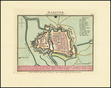
An exquisite rendering of the Saxon metropolis, Magdeburg, this bird's-eye view is a product of the renowned collaboration between Georg Braun and Frans Hogenberg, from their seminal work, the six-volume Civitates Orbis Terrarum. Created circa 1572, this representation furnishes a vivid, bird's-eye perspective of the city, capturing its Gothic architectural triumphs and robust fortifications, a testament to its historical power and prestige.
Couched within the broad ambit of the Renaissance, the Civitates Orbis Terrarum marked an epoch in the art of city mapping, an intermingling of art, geography, and topography. The collaborative effort of Braun, a cleric and editor, and Hogenberg, an engraver, was instrumental in this evolution, and their city maps, such as the present one of Magdeburg, encapsulate the essence of this transformative period.
The depiction of Magdeburg—once known as Parthenopolis in reverence to Venus—offers a detailed urban panorama, highlighting its remarkable structures and the physical geography of its environs. The iconic Gothic cathedral of SS Maurice and Catherine, the fortified castle, St John's church—the pulpit for Martin Luther in 1524—and the town hall fronting the Alter Markt, are all immortalized with remarkable precision. The map delineates the narrow city walls and its location by the Elbe, emblematic of its strategic and economic importance, as the accompanying cartouche text elucidates.
The inclusion of Magdeburg in the Civitates Orbis Terrarum underscores its significance as a key urban center during the Renaissance. Braun's commentary enhances our understanding of the city's historical context, emphasizing its noble stature, architectural grandeur, and unique administrative role in the burgraviate. The Magdeburg depiction stands as a historical document and a work of art, encapsulating the essence of a city that, in its time, embodied wealth, power, and cultural richness.
Georg Braun (1541-1622) was born and died in Cologne. His primary vocation was as Catholic cleric; he spent thirty-seven years as canon and dean at the church St. Maria ad Gradus, in Cologne. Braun was the chief editor of the Civitates orbis terrarum, the greatest book of town views ever published. His job entailed hiring artists, acquiring source material for the maps and views, and writing the text. In this role, he was assisted by Abraham Ortelius. Braun lived into his 80s, and he was the only member of the original team to witness the publication of the sixth volume in 1617.
Frans Hogenberg (ca. 1540-ca. 1590) was a Flemish and German engraver and mapmaker who also painted. He was born in Mechelen, south of Antwerp, the son of wood engraver and etcher Nicolas Hogenberg. Together with his father, brother (Remigius), uncle, and cousins, Frans was one member of a prominent artistic family in the Netherlands.
During the 1550s, Frans worked in Antwerp with the famous mapmaker Abraham Ortelius. There, he engraved the maps for Ortelius’ groundbreaking first atlas, published in Antwerp in 1570, along with Johannes van Deotecum and Ambrosius and Ferdinand Arsenius. It is suspected he engraved the title page as well. Later, Ortelius supported Hogenberg with information for a different project, the Civitates orbis terrarium (edited by Georg Braun, engraved by Hogenberg, published in six volumes, Cologne, 1572-1617). Hogenberg engraved the majority of the work’s 546 prospects and views.
It is possible that Frans spent some time in England while fleeing from religious persecution, but he was living and working in Cologne by 1580. That is the city where he died around 1590. In addition to his maps, he is known for his historical allegories and portraits. His brother, Remigius, also went on to some fame as an engraver, and he died around the same time as his brother.
![[ Elbe River ] Celeberrimi Fluvii Albis nova delineatio Auctore Christiano Mollero . . . 1628](https://storage.googleapis.com/raremaps/img/small/99230.jpg)
![Holsatiae Descriptio [with] Rugiae Usedomiae et Iulinae Wandalicarum insularum Vera descrtiptio 1584](https://storage.googleapis.com/raremaps/img/small/83746.jpg)