|
||

|

|
|

|
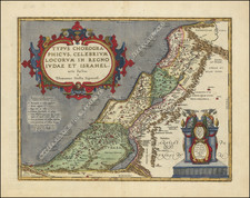
Interesting early map of the Holy Land, which appeared in the 1538 edition of Solinus' Polyhistor, rerum toto orbe memorabilium thesaurus locupletissimus. Huic ob argumenti similitudinem Pomponii Melae de situ orbis libros tres adiunximus.
The map provides an excellent early depiction of the region from Sidon in the north, to Gaza in the South. The map also shows the Dead Sea, Jordan River, and Sea of Galilee.
Solinus was a third century Latin Scholar, who compiled a number of earlier ancient works in his Polyhistor, which contains a short description of the ancient world, with remarks on historical, social, religious and natural history questions. Much of the work is drawn from Pliny's work on Natural History and Pomponius Mela's work on Geography.