|
||

|

|
|

|
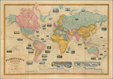
Fascinating World map, which was engraved to accompany Johannes Kepler's Tabulae Rudolphinae, a copy of which is offered here, with the map.
The present example is the Pierre Béres copy. An iconic map among collectors, the map was engraved to accompany Kepler's monumental Tabulae Rudolphinae of 1627.
On his deathbed in 1601, Tycho Brahe urged Johannes Kepler to complete Tycho's long-projected astronomical tables, to be based on Tycho's mass of astronomical observations and named after their patron Rudolph II. As Tycho Brahe's successor in the post of imperial mathematician, Kepler's principal task was the preparation of these improved astronomical tables. He worked on them for years.
In his own eyes Kepler was a speculative physicist and cosmologist; to his imperial employers he was a mathematician charged with completing Tycho's planetary tables. He spent most of his working years with this task hanging as a burden as well as a challenge; ultimately it provided the chief vehicle for the recognition of his astronomical accomplishments (DSB).
When the work was finally ready for the press in 1624, there were further delays, including the arrival of the Counter-Reformation in Linz, where Kepler was living and had planned to have the work printed. The edition was finally printed in Ulm, under Kepler's close supervision, in an edition of 1000 copies.
In excusing the long delay in publication... [Kepler] mentioned in the preface [p. 6] not only the difficulties of obtaining his salary and of the wartime conditions but also 'the novelty of my discoveries and the unexpected transfer of the whole of astronomy from fictitious circles to natural causes, which were most profound to investigate, difficult to explain, and difficult to calculate, since mine was the first attempt'" (DSB).
The greatly improved accuracy of Kepler's tables over previous planetary tables was due not only to his adherence to the Copernican system and his discovery of the laws of planetary motion, but also to the "happy calamity," as he put it, of his initiation into logarithms, through the intermediary of a small book by Benjamin Ursinus (the Cursus mathematici practici, Cologne 1618) which reproduced Napier's tables of logarithms. Kepler created his own logarithmic tables (published in 1624), and used them for the complex calculations required to determine planetary orbits.
The superiority of his tables "constituted a strong endorsement of the Copernican system, and insured the tables' dominance in the field of astronomy throughout the seventeenth century" (Norman). The Tabulae Rudolphinae . . . is a monumental work in which Kepler provided the data by which the positions of the planets could be computed. It was the first book to require the use of logarithms which had recently been invented by John Napier . Kepler's tables were about 30 times better than any previous ones and were the primary source of recognition for his work in astronomy in the decades following their publication. He used the tables to predict a transit of Mercury which was observed by Pierre Gassendi in 1631. This successful observation added weight to the case for Copernicanism.
The map was designed and engraved by the Nuremberg cartographer Philip Eckebrecht at the request of his friend Johann Kepler . This magnificent map was apparently intended to illustrate a future edition of the Tabulae Rudolphinae, used for calculating longitude. The first edition of the tables was published in 1627, and the map is occasionally found inserted in some copies. The dating of the map as circa 1658 is derived from the dedication to Leopold I, who became Holy Roman Emperor in that year.
The map is decorated with a two-headed eagle of the Holy Roman Empire.
The map was once considered to be the first to show the Dutch explorations in Australia, but the later dating of this map now negates this idea. It is possible that an earlier issue of this map exists without the dedication to Leopold I, but the plate does not look unduly altered. It seems likely that this map was planned by Kepler for inclusion in a future edition of the tables, but unfortunately on his death in 1630, the copper plate was probably left unfinished or indeed unpaid, and was probably retained by his executors or Walch in an unfinished state, and was subsequently completed some 28 years later.
The description of the book is as follows:
KEPLER, JOHANNES - Tabulae Rudolphinae … Ulm, Johannes Saur 1627 - 1629.
Folio (cm 35), attractive contemporary calf with golden fillets on covers, gilt spine with golden title, fillets and tools, very light browning for the usual quality of the paper, printed titlepage reinforced at the inner margin, near to the sewing. A copy with good, wide margins.
Text on 2 cols., many diagrams and woodcuts, the 2nd part has numerical tables; woodcut initials and tailpieces. Pp. (16), 120; 121-128 (Sportula); 119, (1b). The engraved frontispiece is supplied in facsimile. The world map was added in a very few copies, as it was engraved after the publication of the main work. The frontispiece is also often missing. First edition. Caspar 79; Houzeau and Lancaster 12754; Lalande p. 190; Norman 1208.
Images of the book are available on request.
Book Description: Folio (cm 35), attractive contemporary calf with golden fillets on covers, gilt spine with golden title, fillets and tools, very light browning for the usual quality of the paper, printed titlepage reinforced at the inner margin, near to the sewing. A copy with good, wide margins.
Text on 2 cols., many diagrams and woodcuts, the 2nd part has numerical tables; woodcut initials and tailpieces. Pp. (16), 120; 121-128 (Sportula); 119, (1b). Frontispiece in facsimile.
![Pour Les Vents [world map centered on Asia]](https://storage.googleapis.com/raremaps/img/small/59768.jpg)
![[World -- Terrestrial Globe Gores]](https://storage.googleapis.com/raremaps/img/small/89195.jpg)