


|
||

|

|
|

|
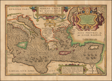
Fine old color example of this interesting historical map of Ortelius's Parergon, illustrating the ships of Troy in the Mediterranean, based upon the descriptions of Virgilius in his Aenaeas.
Designed with two decorative cartouches, one located next to the title in the upper right hand corner with the Christogram in the shield. The bottom cartouche includes a passage from The Aeneid;
The good Aeneas I am call'd,
While Fortune favor'd, not unknown to fame.
My household gods, companions of my woes,
With pious care I rescued from our foes.
To fruitful Italy my course was bent;
And from the King of Heav'n is my descent.
With twice ten sail I cross'd the Phrygian sea;
Fate and my mother goddess led my way.
Scarce sev'n, the thin remainders of my fleet,
From storms preserv'd, within your harbor meet.
Myself distress'd, an exile, and unknown,
Debarr'd from Europe, and from Asia thrown.
The Aeneid is a Latin epic poem, written by Virgil between 29 and 19 BC, that tells the legendary story of Aeneas, a Trojan who travelled to Italy, where he became the ancestor of the Romans. The first six of the poem's twelve books tell the story of Aeneas's wanderings from Troy to Italy and the poem's second half tells of the Trojans' ultimately victorious war upon the Latins.
Following the destruction of Troy, Aenaeas was reported to have roamed the seas for 7 years, beginning with a fleet of 20 ships, of which only 7 survived the 7 year ordeal.
Abraham Ortelius is perhaps the best known and most frequently collected of all sixteenth-century mapmakers. Ortelius started his career as a map colorist. In 1547 he entered the Antwerp guild of St Luke as afsetter van Karten. His early career was as a business man, and most of his journeys before 1560, were for commercial purposes. In 1560, while traveling with Gerard Mercator to Trier, Lorraine, and Poitiers, he seems to have been attracted, largely by Mercator’s influence, towards a career as a scientific geographer. From that point forward, he devoted himself to the compilation of his Theatrum Orbis Terrarum (Theatre of the World), which would become the first modern atlas.
In 1564 he completed his “mappemonde", an eight-sheet map of the world. The only extant copy of this great map is in the library of the University of Basel. Ortelius also published a map of Egypt in 1565, a plan of Brittenburg Castle on the coast of the Netherlands, and a map of Asia, prior to 1570.
On May 20, 1570, Ortelius’ Theatrum Orbis Terrarum first appeared in an edition of 70 maps. By the time of his death in 1598, a total of 25 editions were published including editions in Latin, Italian, German, French, and Dutch. Later editions would also be issued in Spanish and English by Ortelius’ successors, Vrients and Plantin, the former adding a number of maps to the atlas, the final edition of which was issued in 1612. Most of the maps in Ortelius' Theatrum were drawn from the works of a number of other mapmakers from around the world; a list of 87 authors is given by Ortelius himself
In 1573, Ortelius published seventeen supplementary maps under the title of Additamentum Theatri Orbis Terrarum. In 1575 he was appointed geographer to the king of Spain, Philip II, on the recommendation of Arias Montanus, who vouched for his orthodoxy (his family, as early as 1535, had fallen under suspicion of Protestantism). In 1578 he laid the basis of a critical treatment of ancient geography with his Synonymia geographica (issued by the Plantin press at Antwerp and republished as Thesaurus geographicus in 1596). In 1584 he issued his Nomenclator Ptolemaicus, a Parergon (a series of maps illustrating ancient history, sacred and secular). Late in life, he also aided Welser in his edition of the Peutinger Table (1598).
![Natolia Detta anticamente Asia Minore . . . 1686 [Shows Cyprus]](https://storage.googleapis.com/raremaps/img/small/76765.jpg)

![La Dimostratione Del Luogo Dove Al Presente Sitrova L'Armat Di Barbarossa, et De Christiani Detto Il Golfo Dell' Artha Antichamente Il Seno Ambracio Da Ambracia Citta Reale Di Pulrrho Vicino Al Promontorio Actio Per Lavictoria Di Augusto Contra Marc Antonio et Cleopatra Memorabile [The Demonstration of the Place Where the Fleet of Barbarossa is Currently Located, and of the Christians, Called the Gulf of Artha, in the Past the Ambracian Gulf, from Ambracia, a Royal City of Pyrrhus, Near the Promontory of Actium, Memorable for the Victory of Augustus Against Mark Antony and Cleopatra.]](https://storage.googleapis.com/raremaps/img/small/73923.jpg)
