|
||

|

|
|

|
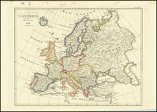
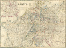
Rare, Highly Decorative “Carte à Figures” Map of Europe from the Dutch Baroque Era
Exceptional map of Europe from the height of Dutch Baroque cartography. This ornate map is one of the finest representations of Europe from the early modern period and features the Baroque “Carte à Figures” style. It is also exceedingly rare on the market.
The map depicts all of the continent of Europe and is surrounded on three sides by panels of fine vignettes. Along the top panel, there are overviews of the towns of Lisbon, Toledo, London, Paris, Rome and Venice. The left side of the map includes depictions of people in local costume from England, France, Belgium, Catalonia and Venice, while the right side includes depictions of individuals from Germany, Hungary, Bohemia, Poland and Greece.
The map is further embellished by a fine title cartouche, which appears in the Atlantic Ocean with two putti on each side. Resting on the cartouche is a clock with Roman numerals that contains a skull surrounded by flames in its center. The imprint appears in the upper right corner, with a pair of wings resting on top of it. The map also contains finer details such as ships sailing the Atlantic and Mediterranean Oceans, lions in North Africa, and bears in Russia.
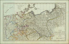
The map reflects contemporary national borders of the seventeenth century. Denmark is still shown to control Scania in Southern Sweden, lands that it would retain until 1658. Sweden is shown to retain Finland, much of the Baltic countries and a part of Prussia, regions it would hold until the early eighteenth century. Parts of what are now northern France, such as Artois and Lille, are still shown to be part of the Spanish Netherlands, while Roussillon, in what is now southern France, is still shown to be part of Spain. These lands would be ceded to France by Spain in 1659. The kingdom of Poland reaches diagonally from Gdynia down to the southeast, past Lvov. Most notably, the Ottoman Empire controls all of southeastern Europe up as far north as a line running through modern Croatia, Hungary and Romania, while also controlling most of the Ukraine. Also of note is the comparatively inaccurate delineation of the north shore of the Black Sea in the Ukraine, which was not scientifically mapped until the 1770s.
The map was originally conceived by Jodocus Hondius the Younger as a part of an exceedingly rare Appendix to the Hondius-Mercator Atlas (1630), which included an extra panel of text at the bottom. The present edition was issued by Hondius's brother-in-law, as part of his Atlas Novus (1638). The present Jansson edition is distinguishable by the appearance of Jansson's imprint within a cartouche to the upper right and the removal of the bottom text panel, which was considered to be too cumbersome for inclusion in a folio atlas.
The Baroque Period and the “Carte à Figures” Style
Jansson’s map coincided with the height of the Dutch Baroque period, which occurred throughout the early and mid-seventeenth century and was characterized by the attempt to evoke an emotional response in the viewer. As a result, Baroque-era works were often ornate and dramatic with a heavy focus on appealing to the senses. Jansson’s ornate map of Europe highlights the influence of the baroque style upon Dutch cartography of the period, in addition to exemplifying the intermixing of art and cartography which characterized the “decorative” phase of mapping. The so-called “scientific” phase of mapping did not begin until the late 1750s.
Additionally, Jansson’s map highlights the “Carte à Figures” style of the time that was also shaped by the influence of the Baroque period. The “Carte à Figures” style featured maps with decorated borders containing images which related to the maps’ contents, such as depictions of people in local costume and depictions of town plans. Publishers often commissioned artists to produce these designs.
Cartography in the Low Countries
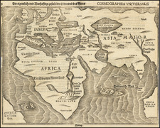
Jansson’s map of Europe is significant not only due to its Baroque style but also due to its place within the tradition of European cartography. Throughout the sixteenth and seventeenth centuries, commercial cartography in the Low Countries witnessed an explosion that can be divided into two periods. The first of these, the southern Dutch period, lasted until 1600 and featured Antwerp as a center of production. In 1570, Abraham Ortelius produced the first text that could be considered a modern world atlas, titled Theatrum orbis terrarium. In 1595, Gerardus Mercator was the first individual to use the term “atlas” in referring to a collection of maps with his text Atlas sive Cosmographicæ meditationes de fabrica mvndi et fabricati figvra.
Decades later, these two texts provided a major basis for the cartographic works of Jansson. In the 1630s, Jansson joined the cartographic publishing house of Henricus Hondius, his brother-in-law. One of the Jansson-Hondius publishing house’s first ventures was the publication of an appendix to the Mercator atlas in 1630 and 1631, titled Appendix. This included the Jodocus Hondius version of this map, with the text block at the bottom.
The Jansson-Hondius partnership was part of the second phase of the explosion of commercial cartography in the Low Countries, which was centered in Amsterdam at the turn of the seventeenth century. This shift was largely motivated by expanding Dutch commerce and voyages of discovery, especially in the East Indies, which created a market for maps, globes, atlases and travel books. Wars against Spain in the northern Low Countries increased the importance of maps as a means of keeping citizens up to date on military news as well as geographic changes such as the construction of new fortifications and territorial gains or losses. The final contributor to the northern Dutch period of cartography was an influx of immigrants—including engravers, publishers and printers—to the north from the southern Low Countries as a result of the Spanish conquests in the Southern Provinces.
One such immigrant was Willem Jansz. Blaeu, who moved to Amsterdam in 1599. A distinguished globemaker and cartographer, Blaeu entered the atlas publishing business in the 1630s. Shortly thereafter, he published his own version of an appendix to the Mercator atlas, titling it Atlantis appendix, sive pars altera. This marked the beginning of an intense rivalry between Blaeu and Jansson. Lasting until their deaths in the 1670s, this rivalry has since been linked with a sharp increase in both the number and quality of atlases produced in Amsterdam throughout the Dutch Baroque period.
Publication and Continuing Influence of Jansson’s Map
At the height of their rivalry in 1638, Jansson and Blaeu both published large, multi-part atlases, titled Atlas novus and Novus atlas, respectively. Jansson’s Atlas novus was a folio-sized set of maps of Europe, the Americas, Asia and Africa. Pieter van den Keere either engraved the set or commissioned it to be engraved. The present map, Nova Europae Descriptio Auctore I. Hondio appears in this text and was based on Jodocus Hondius’ earlier map. While the maps of Africa and Asia were dated to 1623, inspiration for Jansson’s map of Europe came from even earlier. Both its geographical content and the drawings of costumed figures closely mirror Blaeu’s map of Europe from 1617. Furthermore, its town views closely follow Hondius’s map of Europe from 1619.
Atlas novus constitutes one of Jansson’s most significant works, and it eventually became a six-part work rivaled only by his publication of Atlas major in 1660. Atlas major included eleven volumes and contained a celestial atlas by Andreas Cellarius, town atlases, a hydrographic atlas and an atlas of the ancient world. It was eclipsed only by Blaeu’s Atlas maior, published in 1662. Both of these atlases are credited with heralding large-scale atlas production and the period of Dutch dominance in commercial cartography.
As part of the seminal Atlas novus, Jansson’s Nova Europae Descriptio Auctore I. Hondio represents one of the finest depictions of Europe from the apogee of Dutch cartography. It is also rare and appears very occasionally on the market. It would make an invaluable addition to any collection of maps related to early modern Europe or, in particular, Dutch cartography.
Jan Janssonius (also known as Johann or Jan Jansson or Janszoon) (1588-1664) was a renowned geographer and publisher of the seventeenth century, when the Dutch dominated map publishing in Europe. Born in Arnhem, Jan was first exposed to the trade via his father, who was also a bookseller and publisher. In 1612, Jan married the daughter of Jodocus Hondius, who was also a prominent mapmaker and seller. Jonssonius’ first maps date from 1616.
In the 1630s, Janssonius worked with his brother-in-law, Henricus Hondius. Their most successful venture was to reissue the Mercator-Hondius atlas. Jodocus Hondius had acquired the plates to the Mercator atlas, first published in 1595, and added 36 additional maps. After Hondius died in 1612, Henricus took over publication; Janssonius joined the venture in 1633. Eventually, the atlas was renamed the Atlas Novus and then the Atlas Major, by which time it had expanded to eleven volumes. Janssonius is also well known for his volume of English county maps, published in 1646.
Janssonius died in Amsterdam in 1664. His son-in-law, Johannes van Waesbergen, took over his business. Eventually, many of Janssonius’ plates were sold to Gerard Valck and Pieter Schenk, who added their names and continued to reissue the maps.
![(Ecclesiastical Atlas) Chorographica Descriptio Provinciarum et Conventuum Fratrum Minorum Francisci Capucinorum [Chorographic Description of the Provinces and Convents of the Friars Minor of Francis Capuchin. . . ]](https://storage.googleapis.com/raremaps/img/small/93059.jpg)