|
||

|

|
|

|
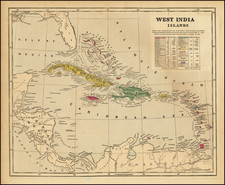
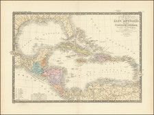
Extremely rare first state of Colom's rare map of the Southeastern US, Gulf Coast, Central America and the Caribbean.
The map is drawn loosely from prior maps by Hessel Gerritsz and Jacob Theunisz, with the nomenclature of North America following the Theunisz very closely, except for the naming of the Cheapeake Bay (Chesape) and the addition of R. Gironde below Port Royal. The map adds internal detail to a number of the rivers previously shown on the Theunisz. The detail along the East Coast of North America and the Gulf Coast are noteworthy, with many early place names.
Burden surmises that the map was published in approximately 1656, as the second state of the map bears this date in the title cartouche. A fascinating note about Bermuda is shown in both English and Dutch at the top of the map. Burden locates only one example in an institutional collection.
Arnold Colom was the son of Jacob Colom, a well regarded Amsterdam bookseller, printer, and chartmaker. Colom produced two sea atlases, a guide and pilot for the Mediterranean and a general sea atlas of the World. Colom's Zee Atlas, published between 1654-58, was one of the largest format sea atlases of the 17th Century, with each chart printed from an oversized copper plate. Koeman describes the atlas as "One of the most important atlases in the well known category of Dutch sea-atlases".
Apart from its rarity, the Zee-Atlas was of importance for its inclusion of the earliest Dutch sea chart of the New Netherlands to appear in an atlas (Jacob Theunisz Lootsman's chart is believed to pre-date it, but seems not to have been regularly published until later), while the "three charts of the oceans are on the same scale (1:14mill.) as Portuguese and Spanish charts of that time. It marked the first time that such charts were published as atlas sheets" (Koeman IV, p.115).