|
||

|

|
|

|
Stock# 34885gm
Description
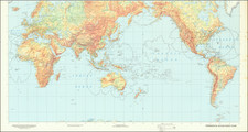
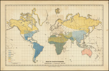
Rare (unrecorded?) variant edition of Antoine De Fer's double hemisphere map of the World, published circa 1660.
The map shows a very unusual configuration of California as an island, along with a massive unknown southern continent and early treatment of the Philippines, Korea (shown as an island) and Japan.
This edition varies from the one described by Shirley(#399), in that it lacks the title, has a different engraver's credit line and other differences outside of the map image. It bears the note that it was engraved by H.Picart and would seem to be a later edition.
Reference
Shirley 399.
![[Hand Drawn Map of the World]](https://storage.googleapis.com/raremaps/img/small/86629.jpg)