


|
||

|

|
|

|
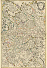
Fine early map of St. Petersburg, published by J.B. Homann.
One of the most decorative of Homann's town plans, dedicated to the city's founder Peter the Great, whose portrait can be seen in the huge title cartouche, surrounded by allegorical figures representing the arts and sciences he nurtured, including ship-building (which he studied in a shipyard in Deptford), printing & geography.
A second map shows the position of the city in the mouth of the River Neva, and a vignette view shows the fortified island 'Crohn Schlot' protecting the city's approaches.
Johann Baptist Homann (1663-1724) was a mapmaker who founded the famous Homann Heirs publishing company. He lived his entire life in Bavaria, particularly in Nuremberg. Initially, Johann trained to become a priest before converting to Protestantism and working as a notary.
In 1702, Johann founded a publishing house that specialized in engravings. The firm flourished, becoming the leading map publisher in Germany and an important entity in the European map market. In 1715, Johann was named Imperial Geographer to the Holy Roman Empire by Charles VI and made a member of the Prussian Academy of Sciences. Most importantly for his business, his reputation and contacts gained him imperial printing privileges which protected his publications and recommended him to customers. Johann is best known for this Grosser Atlas ueber die ganze Welt, or the Grand Atlas of the World, published in 1716.
After Johann died in 1724, the business passed to his son, Christoph (1703-1730). Upon Christoph’s early death, the company passed to subsequent heirs, with the name of the company changing to Homann Erben, or Homann Heirs. The firm continued in business until 1848.
![[Uniforms and Insignia of the German Army] Форма Обмундирования и Знаки Различия Германской Армии](https://storage.googleapis.com/raremaps/img/small/67803.jpg)
![Russian Empire [with] Chart of the Communication Between The Archipelago And Black Sea](https://storage.googleapis.com/raremaps/img/small/64013.jpg)