|
||

|

|
|

|
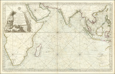
Rare sea chart of the area from Guinea to the Cape of Good Hope, with a large inset of the South African coastline, from the Bay of St. Martin to the Cape of Good Hope.
Unrecorded chart of the southwest coast of Africa, with a highly detailed inset of the South African Coastline, by Johannes Loots. The chart is provides excellent detail, in the style of working sea charts of the late 17th Century. While Loots was a well known maker of sea charts, all of his works are of the utmost rarity, in large part because they were generally sold separately and used at sea by Dutch Mariners.
Johannes Loots (1665 - 1726) was a publisher of sea charts who was active from the 1693 until his death in 1726. Loots began his career as an apprentice to Hendrick Doncker and later set up his own shop on Nieuwebrugsteeg in Amsterdam, in 1693. Between 1695 and 1698, Loots, Claes de Vries (a surveyor-cartographer) and Antoni de Winter (an engraver) entered into a joint venture to produce 200 sea charts on a Mercator Projection (Van Keulen Cartography, p 46). The plans were advertised in the Amsterdamsche Courant in August and October 1698 and several charts offered separately. However, the venture only produced 120 charts (Van Keulen Cartography, p. 47), and the partnership dissolved in 1707, with Claas de Vries selling at least 17 charts, including 16 large plates of the English Channel and a smaller plate of the Hull River, to Gerard Van Keulen on September 24, 1707 for 374 guilders) (Van Keulen Cartography, p. 16).
In 1707, Loots sold 100 charts on a Mercator Projection to Gerard Van Keulen. In 1707, Loots would appear to have purchased the plates of Jacob Robijn, which included the charts originally engraved by Arent Roggeveen for his Burnng Fen. These include a rare set of charts of the North American and Caribbean Coastlines, which were a significant improvement over the contemporary sea charts issued by Van Loon and Goos (for whom Roggeveen had originally made the charts).
At some point, he or his widow must have re-acquired the plates, as his widow and her brother, Isaac Swigerts, continued to publish later editions of some of the charts until 1750, when Swigerts,sold the remainder of the Loots charts to Johannes Van Keulen II. These plates were re-engraved to include the Van Keulen name thereafter. At the time of his death, the inventory notes The inventory of Isaac Swigters estate includes 10,816 various maps, presumably, his unsold inventory.
During the life of Loots sea charts, it is known that some of the charts were copied by both Seller and Grierson.
While an inventory of Loots shop included 464 copperplates, the number of plates known to have been published by Loots is far fewer and it would appear that this inventory included multi-plate charts and non-cartographic material.
Loots' charts are extremely rare on the market. In 2011, when we acquired a group of approximately 10 charts and chart fragments from a small working atlas of Loots, AMPR recorded total of only 5 records of Loots charts offered for sale at auction or dealer catalogues in the prior 30 years.
![Juta's Map of South Africa From The Cape To The Zambesi Compiled from the best available Colonial and Imperial Information Including The Official Cape Colony Map By The Surveyor General, Cape Town, Dr. T.Hahn's Damaraland, And E.C.Selous' Journals & Sketches &c. New and Revised Edition .. . . 1889 [2 Sheets in slipcase]](https://storage.googleapis.com/raremaps/img/small/85389.jpg)
![Colton's Africa [Southern Sheet]](https://storage.googleapis.com/raremaps/img/small/98349.jpg)