


|
||

|

|
|

|
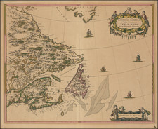
Fine old color example of this important early map of Eastern Canada, etc., from the 1662 Latin edition of Blaeu's Atlas Maior.
Blaeu bases his map of Samuel de Champlain's great map of 1632 and maps of the Dutch East India Company (VOC), by Hessel Gerritsz, which have been augmented with place names from De Laet and Jansson. Blaeu's version shows Nova Scotia, Newfoundland, the Gulf of St. Lawrence, Labrador and the Davis and Hudson Straits as well as the southern tip of Greenland. As noted in Arkway Catalogue 53 (1994):
It was the most extensive and accurate portrayal of New France available at that time, due largely to the fact that it was carefully copied from Champlain's map of 1632.
The elaborate title cartouches symbolize the importance of the Grand Banks fisheries, which are boldly engraved on the map. Latin text on verso. Due to the fire in 1672 in Blaeu's workshop, the map is scarce on the market, as only five issues of the Atlas containing this map were published.
Joan, or Johannes, Blaeu (1596-1673) was the son of Willem Janszoon Blaeu. He inherited his father’s meticulous and striking mapmaking style and continued the Blaeu workshop until it burned in 1672. Initially, Joan trained as a lawyer, but he decided to join his father’s business rather than practice.
After his father’s death in 1638, Joan and his brother, Cornelis, took over their father’s shop and Joan took on his work as hydrographer to the Dutch East India Company. Joan brought out many important works, including Nova et Accuratissima Terrarum Orbis Tabula, a world map to commemorate the Peace of Westphalia which brought news of Abel Tasman’s voyages in the Pacific to the attention of Europe. This map was used as a template for the world map set in the floor of the Amsterdam Town Hall, the Groote Burger-Zaal, in 1655.
Joan also modified and greatly expanded his father’s Atlas novus, first published in 1635. All the while, Joan was honing his own atlas. He published the Atlas maior between 1662 and 1672. It is one of the most sought-after atlases by collectors and institutions today due to the attention to the detail, quality, and beauty of the maps. He is also known for his town plans and wall maps of the continents. Joan’s productivity slammed to a halt in 1672, when a fire completely destroyed his workshop and stock. Joan died a year later and is buried in the Westerkerk in Amsterdam.
![Partie du Cours du Fleuve de Saint Laurent depuis Quebec jusqu'au Cap aux Oyes [on sheet with] Carte du Cours du Fleuve Saint Laurent depuis Quebec jusqu'a la Mer en Deux Feuilles ... 1761](https://storage.googleapis.com/raremaps/img/small/55185.jpg)