


|
||

|

|
|

|
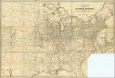
Scarce map of the United States, showing a number of early and transitional territorial configurations. Indiana Territory is directly below Lake Michigan, with Illinois pushed far west of its true location. Mississippi Territory is shown and includes Alabama. Misconfigured Ohio and and Michigan Territories. Louisiana is shown, as is the former Neu Orleans territory, which briefly existed during the Spanish and French control of the region. Masive Missury Territory. Excellent detail, including forts, Indian Tribes, and other interesting details. Nice detail in Florida.
Johann, or Johannes, Walch (1757-1816) was a painter and engraver. He was well-known for painting miniature portraits, having trained in Geneva, Venice, and Rome. Walch published several atlases and sheet maps. As with his atlases, many of Walch’s maps were reprinted after his death.
![[Unusual Italian Immigrant Communities shown!] America Settentrionale, Centrale e Meridionale -- Carta Dimostrativa Delle Ambasciate, Legazioni, Consolati (Con Le Risettive Circoscrizioni Territoriali), Camere Di Commercio, Agenzie Commerciali, Stazion Enotecniche, Uffici Postali, Ospedali, Scuole Governative e Sussidiate All'Estero](https://storage.googleapis.com/raremaps/img/small/86098.jpg)
![Trails: [1595-1945]: Land, Sea, and Air of The American Adventure Series](https://storage.googleapis.com/raremaps/img/small/70672.jpg)