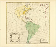
![[ Sea of the West ] L'Amerique divisee en ses principaux Etats . . . By Paolo Santini / Giovanni Antonio Remondini](https://storage.googleapis.com/raremaps/img/small/103460.jpg)


|
||

|

|
|

|
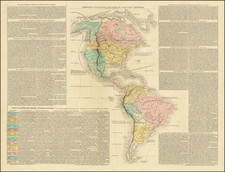
Striking map of America, showing massive Seam of the West, Mississippi & tributaries, Colonies, excellent detail in southwest along Rio Grande, and strangely misspelled L.Winnepeg with rivers connecting it to Hudson Bay & the Mississippi. Large decorative cartouche. Davis land, discovered in 1687 is shown, along with Quiros discoveries in 1605. The entry to the Sea of the West discovered by Juan De Fuca in 1591 and by Martin D'Aguilar in 1603 are note quite prominently and of course mythically. No mention of the mythical early Chinese contact with the NW Coast of America.
Paolo Santini (1729-1793) was an Venetian engraver known especially for his religious prints and fine cartographic engravings. He published in Venice and may have a been a member of the clergy. In his maps, he largely adopted and adapted the work of his French counterparts, especially the brothers de Vaugondy.