|
||

|

|
|

|
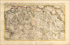
Rare Jeremias Wolff map of the Holy Roman Empire, with emphasis on the postal routes.
The map is divided into its ten imperial circles. It not only highlights major cities and towns but also details the postal stations and the distances between them.
The map includes a detailed legend specifying the number of postal stations between various locations. The title, written in German, indicates that the map was intended for individuals requiring precise and practical information about postal routes, showcasing the postal infrastructure of the time. Wolff's work, enriched with a special dedication to the Holy Roman Emperor, underscores its significance and utility for contemporary users.
In the early 18th century, the Holy Roman Empire was a complex and fragmented entity, composed of numerous principalities, duchies, and free cities. This map, with its detailed division into ten imperial circles, provides a window into the administrative and territorial organization of the empire. The inclusion of postal routes and stations highlights the burgeoning importance of communication and travel in this period, reflecting the evolving infrastructure that supported commerce, governance, and personal correspondence.
The map is richly detailed, with each imperial circle distinctly outlined and major towns and cities clearly marked. The careful notation of postal stations and routes provides insight into the practicalities of travel and communication during this period. The legend on the map clarifies that the numerical figures indicate the number of postal stations between two points, with each station representing two German miles.

![[Zandvliet] Caerte van't Scheldt ende Santvliet; Vertoonede de verdroncken overwaterde Landen, nieuw aengewasse gorsingen, en de kreeken ost killen in en door de Selve tussche Begen op Zoom en Antwerpen. Van nieus Verbetert door C.J. Visscher. 1640](https://storage.googleapis.com/raremaps/img/small/75366.jpg)
![[Brielle] Brilium Holandiae Opp. . . .](https://storage.googleapis.com/raremaps/img/small/89292.jpg)
![Daniae Regni Typus [with] Cimbricae Chersonese nunc Iutiae descriptio ..](https://storage.googleapis.com/raremaps/img/small/94423.jpg)