|
||

|

|
|

|
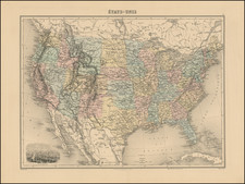
Fascinating map of the United States, which appeared in Frederick Law Olmstead's The Cotton Kingdom: a Traveller's Observations on Cotton and Slavery in the American Slave States, published in New York in 1861.
This map, produced by Frederick Law Olmsted, depicts the cotton-producing regions of the United States and areas with significant slave populations around the mid-19th century. Based on data from the United States Census of 1850, it provides a detailed view of the southeastern United States, including South Carolina, Georgia, Florida, Alabama, Mississippi, Louisiana, Texas, and parts of Arkansas, Missouri, Tennessee, Kentucky, and the Indian Territory.
The map uses blue to indicate Dominant Cotton Districts, which produce two bales or more per slave. Yellow marks Subordinate Cotton Districts, producing less than two bales per slave. Red signifies Subsidiary Slave Districts, which produce no cotton or less than half a bale per slave. Full horizontal lines show districts with a strong slave property interest, where slaves outnumber freemen. Dotted horizontal lines indicate a moderate slave property interest. Regions not covered by horizontal lines but within colored areas represent places where the free population is more than double that of the slaves, though still influenced by slavery.
Olmsted, who traveled extensively in the South before the Civil War and documented its conditions in three volumes, aimed to highlight that areas most committed to slavery were not necessarily the highest cotton producers. This map, included in his work "Journeys and Explorations in the Cotton Kingdom," was part of his advocacy against slavery. He argued that ending slavery would not disrupt cotton production or increase prices, contrary to claims by Southern merchants and diplomats.
The map’s complexity and innovative use of statistical data made it a significant contribution to cartography, despite not accounting for factors like soil quality and rainfall. It visually represented the inefficiency of the Southern slave system and sought to influence British opinion against supporting the Confederacy. Olmsted, known for his work as a landscape architect and his role in the U.S. Sanitary Commission, used his travels and research to argue that the Southern system enriched a few while impoverishing the majority and causing unnecessary suffering for the enslaved.
Frederick Law Olmsted (1822 – 1903) was an American Journalist, Architect and Designer, who is widely considered the father of American landscape architecture.
Olmstead is most famous for designing many well-known urban parks, including Central Park and Prospect Park in New York City.
![[ Cape Hatteras to New York City ] The Coast of the United States of North America; from New York to St. Augustine: Drawn and regulated according to the latest Surveys and Astronomical Observations By Edmund Blunt. Additions to 1839 & 1840](https://storage.googleapis.com/raremaps/img/small/84684.jpg)
![[ English Plantations in North America ] A New Map of the most Considerable Plantations of the English In America Dedicated to His Highness William Duke of Glocester.](https://storage.googleapis.com/raremaps/img/small/98233.jpg)
![[ Benjamin Franklin ] Franklin at the Court of France, 1778. Receiving the homage of his Genius, and the Recognition of his Country's advent among the Nations.](https://storage.googleapis.com/raremaps/img/small/85959.jpg)