


|
||

|

|
|

|
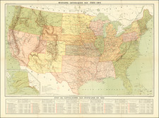
Interesting early map of the United States, published in Paris.
The map includes several geo-political borders which existed for only a short period of time, including Mississippi Territory before the creation of Alabama, and a massive Indiana, which includes all of Illinois. The region west of the Mississippi is still Louisiana Territory, with no subdivisions yet added.
Includes and early depiction of Michigan Territory. The depiction of the Mississippi River north of the Missouri River, and St. Louis is not yet shown.
East and West Florida are also still shown.
The topographical detail of the map is extraordinary, as its its depiction of early Indian Tribes, forts, mountain ranges and rivers.
This is an early state of the map, which would be revised by 1816.

![[Hand Drawn School Girl Map] United States](https://storage.googleapis.com/raremaps/img/small/67904.jpg)