


|
||

|

|
|

|
Feliciana Depicted For The Southern Part of Louisiana
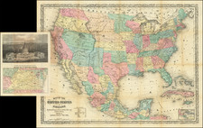
Interesting early map of the United States, published in Paris.
The map includes several geo-political borders which existed for only a short period of time, including Mississippi Territory before the creation of Alabama, and a massive Indiana, which includes all of Illinois. The region west of the Mississippi is still Louisiana Territory, with no subdivisions yet added.
Includes a very early appearance of Michigan Territory. The depiction of the Mississippi River north of the Missouri River has been corrected and St. Louis is now shown. Also, the hydrographical features of the map west of the Mississippi is significantly improved, in comparison with the 1810 state of the map.
East and West Florida are also still shown.
Feliciana
Feliciana Parish, or New Feliciana, was a parish of the Territory of Orleans and the state of Louisiana, formed in 1810 from West Florida territory. It was divided in 1824 into East Feliciana Parish and West Feliciana Parish. Formerly part of the French La Louisiane, the area was settled largely by French colonists by about 1775, when it came under Spanish control during the American Revolutionary War. Feliciana is named for named by Marie Félicité St. Maxent, wife of the Spanish Governor Galvez.
Following the end of the American Revolution, the part of today's Louisiana which is east of the Mississippi River and north of Lake Pontchartrain was under Spanish Control until 1810. The area remained in controversy, even after the Louisiana Purchase. The West Florida section of what is now the state of Louisiana, was not included and terms of the Louisiana Purchase wers vague as to defining its eastern boundary. Though President Jefferson insisted that this area was American, Spain disagreed and continued their occupation.
Feliciana residents were generally not happy with Spanish rule and in 1810 established the short-lived Republic of West Florida. The Republic sought annexion with the Madison administration, and in October 1810, the area was declared to be part of the Louisiana Purchase and therefore the United States Territory.
Initially classified as "Feliciana County" and part of the Territory of Orleans, the a area was later subdivided into New Feliciana, East Baton Rouge, St. Helena, and St. Tammany. In 1812, when Louisiana was admitted to the Union, Feliciana Parish was included.
![A New and Correct Map of North America with the West India Islands, Divided According to the Last Treaty of Peace ... 20th of Jan. 1783 ... Particularly Distinguished the Thirteen Provinces which Compose the United States . . . [With annotations describing Cumberland, Tennessee, Kentucky etc.]](https://storage.googleapis.com/raremaps/img/small/41651.jpg)
![Louisiana [Large-Paper Example]](https://storage.googleapis.com/raremaps/img/small/83278.jpg)
![[ United States ]](https://storage.googleapis.com/raremaps/img/small/83405.jpg)
![[Uncut promotional broadsides for ] Map of the Surface-Feeding Ducks, Swans and Geese of North America](https://storage.googleapis.com/raremaps/img/small/92052.jpg)