This item has been sold, but you can enter your email address to be notified if another example becomes available.


|
||

|

|
|

|
Stock# 104427
Description
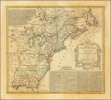
Interesting map of the United States, published in about 1800 in Paris.
The map shows United States on the eve of the Louisiana Purchase. Kentucky, which became a state in 1792, is still not shown. Georgia extends from the Atlantic Ocean to the Mississippi River and both East and West Florida appear.
The map does not yet show Ohio, but a nascent Indiana appears to the southwest of Pennsylvania.
The map is filled with Native American place names and early Forts west of the Appalachian Mountains.
![[The Russian Question] Die Russische Frage. Ein Schauspiel von K. Simonow](https://storage.googleapis.com/raremaps/img/small/83978.jpg)