|
||

|

|
|

|
Stock# 103146
Description
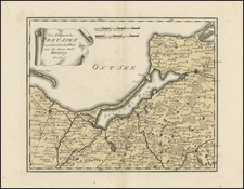
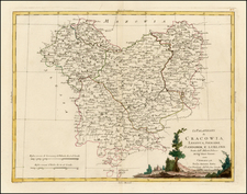
Very scarce regional map of Poland, showing the region bounded by the Weichsel River, Wartha River and Oder River and including Warsaw, Rawa, Lowicz, Sieradz, Piotrkow, Breslau, Brieg, Posen and Leczyka. The major walled cities include a series of dates. Shows rivers, roads, towns, castles, forests, lakes and a host of other details. Quite possibly the most detailed map of this region to appear in an 18th Century Atlas. From Von Reilly's exceedingly scarce Grosser Deutscher Atlas. Von Reilley & Schaembl led a revival of map making in Vienna in the late 18th Century which included this and several other sought after works.
Condition Description
Engraving on 18th-century laid paper. Original hand-color. Minor toning at centerfold. Minor foxing in blank borders.
![[ Duchy of Warsaw ] Polen im Herzogthum Warschau und unter Oestreich und Russland getheilt](https://storage.googleapis.com/raremaps/img/small/98514.jpg)