|
||

|

|
|

|
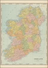
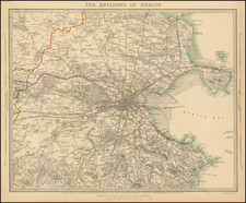
Scarce 19th-century map of Ireland by Henry Teesdale.
The map delineates and labels the counties of Ireland. It also includes the routes of the Dublin and Kildare Mail Coaches.
Many towns and villages are labeled. Roads are shown. Topography is rendered with hachures.
Teesdale was a London-based map publisher. He was an early Fellow of the Royal Geographical Society, elected in 1830. Teesdale partnered with John Hordan and William Colling Hodson, but this arrangement dissolved in 1832. Afterward, he continued to work on his own and periodically with colleagues like John Crane Dower, Christopher Greenwood, Josiah Henshall and others. He published a variety of atlases and separately-issued maps. His business was quite successful, as he registered as a partner in the Royal Bank of Scotland in 1845.
![[ Ireland ] Hiberniae Regnum tam in praecipuas Ultoniae, Connaciae, Lageniae, et Momoniae. . .](https://storage.googleapis.com/raremaps/img/small/78023.jpg)