|
||

|

|
|

|
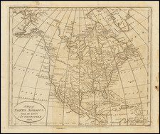
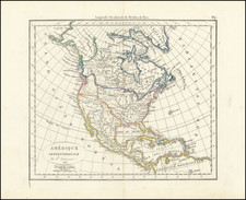
Nice example of Conrad Malte-Brun's attractive 1812 engraved map of North America.
Issued shortly before the publication of Lewis & Clark's 1814 report, the map illustrates the Transmississippi West with remarkable detail, including showing the R. Clarke as a northern fork of the Columbia River, which in its northernmost extension is conflated with the Fraser River.
Near the Rocky Mountains, the name "Campe de Baroney" is an early reference to the location of Baroney ( Antoine Francois Baronet Vasquez, a Spanish Indian Trader from the St. Louis area), who aided Zebulon Pike on his expedition to the Rocky Mountains in 1806. A bit further south on the Arkansas River is Camp Fortifie, likely another Pike related campl.
The map shows several of the mythical rivers of the west, most notably the R. S. Felipe, connecting Lake Timpanagos and Lake Teguyo with San Francisco Bay and and the Pacific.
![[Signed Political Satire Artwork] Vietnam ... Vietnam ... Vietnam ...](https://storage.googleapis.com/raremaps/img/small/68726.jpg)