|
||

|

|
|

|
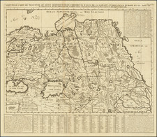
Persia on the Eve of the Russo-Persian War of 1826-1828
This meticulously crafted map of Qajar dynasty Persia presents an in-depth illustration of the extensive empire before the onslaught of the last Russo-Persian War. Every intricate detail on this map offers a glimpse into a time where Persia stood strong, its borders expanding and pushing against neighbouring territories.
The landscape of Persia encapsulates territories such as Irakijemi, or Jibāl, also known as Persian Iraq, and Aderbijan, the region now known as Azerbaijan, along with Kohistan, and Kerman. The map is also informative of the then recently-conceded territories bordering Persia—namely, Armenia, Georgia, and Dagestan, which had been passed over to the Russian Empire.
Furthermore, the map stretches its boundaries to include regions of Central Asia, extending northward to the Aral Sea and moving east towards Jaisalmer. The care and attention to detail are palpable in the delineation of boundaries—dashed lines to illustrate international boundaries, while dotted lines mark the provincial borders within the empire.
A testament to its exhaustive nature, the map does not fail to highlight both modern and ancient cities, creating a blend of the past and present. Cities such as Teheran (Tehran), Rai (Ray), Samarcand (Samarkand), Tashkund (Tashkent), Nissa (Nisa), Shawroot (Shahrud), Moultan (Multan), and Balk (Balkh) grace the landscape of this map. It's remarkable how these cities, though known by different names today, have held onto their historical importance through the passage of time.
The map also provides an insight into the Russian Empire with locations like Catherinegrad, likely the Ekaterinogradskaya, the former administrative center of the Caucasus Oblast, settled on the Terek River west of Mozdok. Further, it features St. George, or Georgiyevsk, a city settled along the Kama (Kuma) River.
Adding a layer of historical context to the map is the marking near Khiva, where the 1717 defeat of Alexander Bekovich-Cherkassky by Uzbek forces is indicated. Bekovich, under the aegis of Peter the Great, was known for spearheading Russia's first military expedition into Central Asia.
Russo-Persian War of 1826-1828
The last Russo-Persian War, also known as the Russo-Persian War of 1826–1828, was a military conflict between the Russian Empire and the Persian Empire, which was then ruled by the Qajar dynasty. It took place against the backdrop of growing Russian influence in the Caucasus region and Persian attempts to maintain control over its territories there.
This conflict was not the first bout of warfare between the two empires. They had already clashed during the Russo-Persian War of 1804–1813, after which Persia was compelled to sign the Treaty of Gulistan, ceding many of its Caucasian territories to Russia.
The later war began in 1826 when the Persian Empire, driven by a desire to regain lost territories and emboldened by what they perceived as Russian military weakness, launched an attack. The Persians initially enjoyed some success. However, their fortunes soon reversed as the Russian Empire managed to mobilize its forces, taking advantage of its superior military technology and organized command structure.
The conflict ended in 1828 with the Treaty of Turkmenchay. This peace accord resulted in Persia acknowledging Russian dominance over the vast majority of the Caucasians territories, including most of modern-day Armenia, Azerbaijan, and Igdir in Turkey. The defeat was a devastating blow to the Qajar Persians, leading to a significant loss of their territories and marking the end of Persia's era of territorial expansion.
The Lizars were a Scottish family of engravers and printers who produced many views and maps. Daniel Lizars Sr. (1754-1812) was the son of a shoemaker, but he apprenticed with Andrew Bell, a printer and engraver. Lizars set up his own printworks near St. Giles Cathedral and took on his own apprentices, including George Bartholomew, whose son John would go on to found the important mapmaking firm later know as John Bartholomew & Son Ltd.
Daniel Sr. had three sons: Daniel Jr., John, and William Home. He also had a daughter, Jane Home. Daniel Jr. (1793-1875), the youngest of the boys, apprenticed in his father’s shop alongside George Bartholomew. When his father died in 1812, Daniel Jr. took over much of the business, expanding it and specializing in maps. The company went bankrupt in 1832, however, and Daniel emigrated to Canada.
John Lizars (1792-1860), the middle son, studied medicine and became Professor of Surgery at the Royal College of Surgeons of Edinburgh, as well as senior surgeon at the Royal Infirmary of Edinburgh.
William Home Lizars (1788-1859), the eldest, also apprenticed in his father’s shop. After learning engraving, William entered the Trustees’ Academy to learn under John Graham. He was a skilled painter and artist. When his father died, and after his Daniel Jr. left, he carried on printing and invented a method of etching that looks like wood engraving.
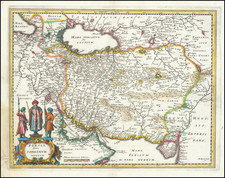
![[ Ancient Persia and Environs ] Regiones Mare Hyrcanum Oxum Fl, et Indicum Pels sitae](https://storage.googleapis.com/raremaps/img/small/102032.jpg)
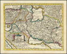
![[ Armenia, Caucasus and Georgia ] Tabula Asiae III](https://storage.googleapis.com/raremaps/img/small/103837.jpg)