


|
||

|

|
|

|
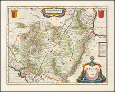
First Modern Map of The Iberian Peninsula (Spain & Portugal) - Based on The Earliest Surviving Manuscript Map of the Iberian Peninsula
Based upon the work of the 2nd Century Alexandrian polymath Claudius Ptolemy, this map is perhaps the single most important modern map of the Iberian Peninsula published in the 15th Century.
Along with the map of Francesco Berlingheri also first published in 1482 in Florence, the present map holds the distinction of being the first modern map of the Iberian Peninsula. It is also the first map to appear to be in its original color and the first published North of the Alps.
The present map differs significantly from Berlinghieri's map, with the present map having an entirely different arrangement of mountains, a thinner peninsular shape, and extends to more outlying islands. While Berlingheri's map ends with Majorca, the present map extends to Minorca and
The map covers all of the Iberian Peninsula, delineating the Kingdoms of Spain and Portugal, the Emirate of Grenada ("Regnum Granate:", still under Muslim control when this map was issued), and the Principality of Catalonia. Major regions, such as Navarre, Biscay, Galicia, Castile, and Andalusia, are named.
Sources
Remarkably, the Berlingheri map of 1482 and the Ulm Ptolemy map of 1482-86 derive from two different originals, the Ulm Ptolemy likely coming from an anonymous manuscript Modern Map of Spain from codex 2586 of the General Library of the University of Salamanca , from the end of the 15th century and the Berlingheri map from a manuscript map of Florentine miniaturist Pietro del Massaio.
As noted above, the present map likely derives from a map found in codex 2586 (a manuscript copy of Ptolemy’s Geographia), which we will refer to herein as the Margarit map, named for its first owner, Cardinal Joan Margarit i Pau, and typically dated 1456 (the date of the codex). While found in a manuscript copy of Ptolemy’s Geographia, the Margarit map was clearly not originally part of this work and was likely cut out to be bound into codes 2586.
It is likely that the Berlingheri map of the Iberian Peninsula derives from the work of Florentine miniaturist Pietro del Massaio, whose manuscripts, dating from before 1456 to 1472, contained maps of Spain, France, and Italy and were noted for their resemblance to each other, yet with varying representational techniques. The following link shows an image of a unique woodcut map of the Iberian Peninsula in the Museo Correr in Venice which follows the configuration of Massio's, which is drawn with south at the top, superimposed over the Margarit map.
For a discussion of the earliest modern maps of Spain, we recommend Roberto Almagia's The First Modern Map of Spain Imago Mundi, 1948, Vol. 5 (1948), pp. 27-31.
The Ulm Ptolemy
The 1482 Ulm edition of Ptolemy's Geographia was the first edition printed north of the Alps map and the first to appear in color which was applied by the publisher. The 1482 Ulm edition of the Geographia was one of the most important cartographic texts of the early Renaissance and the first edition of the work to be printed outside Italy. The text for this edition was based upon a manuscript translated into Latin by Jacobus Angeli and edited by Nicolaus Germanus that had been brought to Ulm from Rome in 1468. The Ulm Ptolemy was first published in 1482 by Lienhart Holle, the same year as Berlingheri's Florence edition. Ashley Baynton Williams notes:
Working independently of Berlinghieri, but apparently using the same or similar models, Holle also added modern maps of Spain, France, Italy and Palestine, but also the first printed map of Scandinavia, composed by Cornelius Clavus, circa 1425-7. Holle's maps were printed from woodcuts, and are characterised by heavy wash colouring for the sea areas, typically a rich blue for the 1482 edition, and an ochre for the 1486 edition. These bright colours, and the greater sense of age that woodcuts convey, make this series the most visually appealing of the [Ptolemeic] maps.
Holle went bankrupt shortly after the original publication and the work was taken over by Johann Reger, who issued a second edition in 1486.
Rarity
Ulm Ptolemy maps are scarce on the market.
This is the first example of the map of Spain we have offered for sale.
Claudius Ptolemy (fl. AD 127-145) was an ancient geographer, astronomer, and mathematician. He is known today through translations and transcriptions of his work, but little is known about his life besides his residence in Alexandria.
Several of his works are still known today, although they have passed through several alterations and languages over the centuries. The Almagest, in thirteen books, discusses astronomy. It is in the Almagest that Ptolemy postulates his geocentric universe. His geometric ideas are contained in the Analemma, and his optical ideas were presented in five books known as the Optica.
His geographic and cartographic work was immensely influential. In the Planisphaerium, Ptolemy discusses the stereographic projection. Perhaps his best-known work is his Geographia, in eight books. However, Ptolemy’s ideas had been absent from western European intellectual history for roughly a thousand years, although Arab scholars interacted with his ideas from the ninth century onward.
In 1295, a Greek monk found a copy of Geographia in Constantinople; the emperor ordered a copy made and the Greek text began to circulate in eastern Europe. In 1393, a Byzantine diplomat brought a copy of the Geographia to Italy, where it was translated into Latin in 1406 and called the Cosmographia. The manuscript maps were first recorded in 1415. These manuscripts, of which there are over eighty extant today, are the descendants of Ptolemy’s work and a now-lost atlas consisting of a world map and 26 regional maps.
When Ptolemy’s work was re-introduced to Western scholarship, it proved radically influential for the understanding and appearance of maps. Ptolemy employs the concept of a graticule, uses latitude and longitude, and orients his maps to the north—concepts we take for granted today. The Geographia’s text is concerned with three main issues with regard to geography: the size and shape of the earth; map projection, i.e. how to represent the world’s curve proportionally on a plane surface; and the corruption of spatial data as it transfers from source to source. The text also contains instructions as to how to map the world on a globe or a plane surface, complete with the only set of geographic coordinates (8000 toponyms, 6400 with coordinates) to survive from the classical world.
![[Cadiz] Isle Ville et Port De Cadis en Espagne de la Province d'Andalousie a 36.D. de Latitude et 12 Degrez 45 Minutes de Longitude](https://storage.googleapis.com/raremaps/img/small/62354.jpg)
![[Grenada] Plano de Granada Comprobado con el Instituto Geogco. y Revisado por arquiteto municipal (Spain)](https://storage.googleapis.com/raremaps/img/small/61742.jpg)
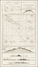
![Valetta, the Capital of the Island of Malta [with] Balearic Islands [and] Corsica and Sardinia](https://storage.googleapis.com/raremaps/img/small/87300.jpg)
![[Madagascar] S. Lorenzo](https://storage.googleapis.com/raremaps/img/small/71937.jpg)