|
||

|

|
|

|
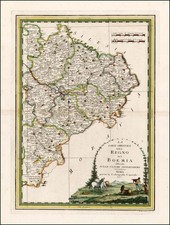
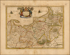
Scarce example of Covens & Mortier's map of Bohemia, Silesia, Moravia and Lusatia.
Includes several coats of arms and a decorative cartouche. This is a later state of Frederick De Wit's map of the same title.
The map offers a detailed cartographic representation of the Habsburg Monarchy's hereditary lands at the beginning of the 18th century. The map showcases the Kingdom of Bohemia and its associated provinces – Silesia, Moravia, and Lusatia – which were integral to the Habsburg dominions. These regions, depicted with notable accuracy, are indicative of the cartographic skills of the era. The map highlights the administrative divisions within the Habsburg territories, providing insight into the political organization and governance of the region during a time of evolving European power dynamics.
In the late 17th and early 18th centuries, these regions were central to the shifting political landscape in Europe. Prague, the capital of Bohemia, along with other major cities such as Wroclaw (Breslau), Brno, and Görlitz, are accurately plotted, emphasizing their importance as administrative and cultural centers. The map also details significant rivers like the Elbe, Oder, and Morava, underlining their roles in trade and transportation, which were crucial for the economic sustenance of the area.
Covens & Mortier was one of the largest and most successful publishing firms in Dutch history and continued in business for over a century. Pierre Mortier the Elder (1661-1711) had obtained a privilege in 1690 to distribute the works of French geographers in the Netherlands. After his widow continued the business for several years, Cornelis (1699-1783) took over in 1719.
In 1721, Mortier forged a partnership with Johannes Covens (1697-1774), who had recently married Cornelis’ sister. They published under the joint name of Covens & Mortier. In 1774, upon the death of his father, Johannes Covens II (1722-1794) took over his father’s share. In 1778, the company changed its name to J. Covens & Zoon, or J. Covens & Son.
Covens II’s son, Cornelis (1764-1825), later inherited the business and brought Petrus Mortier IV back into the fold. Petrus was the great-grandson of Petrus Mortier I. From 1794, the business was called Mortier, Covens & Zoon, or Mortier, Covens, & Son.
The business specialized in publishing French geographers including Deslisle, Jaillot, Janssonius, and Sanson. They also published atlases, for example a 1725 reissue of Frederik de Wit’s Atlas Major and an atlas, with additions, from the works of Guillaume Delisle. There were also Covens & Mortier pocket atlases and town atlases. The company profited from acquiring plates from other geographers as well. For example, the purchased Pieter van der Aa’s plates in 1730. Finally, they also compiled a few maps in house. At their height, they had the largest collection of geographic prints ever assembled in Amsterdam.