|
||

|

|
|

|
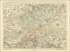
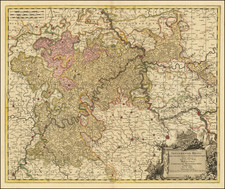
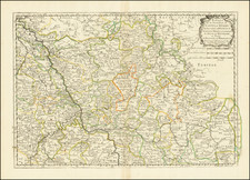
Vincenzo Coronelli's map of the Electorate of Cologne is a remarkable antique map that showcases the skilled craftsmanship and attention to detail characteristic of Coronelli's work. This two-sheet map focuses on a captivating section of the Rhine River, between Wesel and Koblenz, offering a comprehensive view of the Electorate of Cologne at the end of the 17th Century.
The map's intricate engravings and precise rendering of geographical features demonstrate Coronelli's talent as a cartographer. Rivers, towns, fortified areas, bridges, and other notable elements are depicted with great care, creating an accurate representation of the region's topography.
Beyond its aesthetic value, this map provides valuable insights into the historical context of the Electorate of Cologne during the 17th and 18th centuries. The region underwent significant political and religious transformations during this time. The map includes various historical notes, highlighting important locations and events, offering a glimpse into the region's past.
Each element on the map contributes to a deeper understanding of the era. Fortified towns indicate the military strategies employed during the period, while churches symbolize the region's religious heritage. The Rhine River, depicted with meticulous detail, served as a vital trade route, connecting towns and settlements that relied on its waters for economic prosperity.
Throughout the map, towns, rivers, and bridges are labeled with precision, emphasizing Coronelli's commitment to accuracy. The bridges, in particular, symbolize the connections and unity among communities along the Rhine, facilitating trade and cultural exchange.
Vincenzo Maria Coronelli (1650-1718) was one of the most influential Italian mapmakers and was known especially for his globes and atlases. The son of a tailor, Vincenzo was apprenticed to a xylographer (a wood block engraver) at a young age. At fifteen he became a novice in a Franciscan monastery. At sixteen he published his first book, the first of 140 publications he would write in his lifetime. The order recognized his intellectual ability and saw him educated in Venice and Rome. He earned a doctorate in theology, but also studied astronomy. By the late 1670s, he was working on geography and was commissioned to create a set of globes for the Duke of Parma. These globes were five feet in diameter. The Parma globes led to Coronelli being named theologian to the Duke and receiving a bigger commission, this one from Louis XIV of France. Coronelli moved to Paris for two years to construct the King’s huge globes, which are 12.5 feet in diameter and weigh 2 tons.
The globes for the French King led to a craze for Coronelli’s work and he traveled Europe making globes for the ultra-elite. By 1705, he had returned to Venice. There, he founded the first geographical society, the Accademia Cosmografica degli Argonauti and was named Cosmographer of the Republic of Venice. He died in 1718.