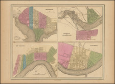
|
||

|

|
|

|
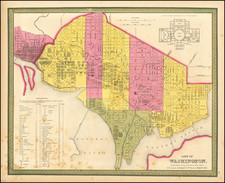
Rare German map of Washington DC, based upon Andrew Ellicott's plan, first published in 1792.
The map appeared in Zimmermann's rare Taschenbuch der Reisen...
Andrew Ellicott Plan of Washington, DC
Andrew Ellicott's Plan of Washington, was the first official map of the City of Washington, then the future capital of the United States.
The site of the permanent American capital remained unsettled for years after the United States gained its independence from Great Britain. Prior to 1790 Congress met variously at Philadelphia, Lancaster and York, Pennsylvania; Annapolis and Baltimore, Maryland; Princeton and Trenton, New Jersey; and New York City.
The location of the permanent capital was not confirmed until the Residence Act of 1790, which provided for a district not more than 10 miles square along the Potomac River, "at some place between the mouths of the Eastern Branch and the Connogocheague." Passage of the Act was made possible by the Compromise of 1790, in which southern states agreed to back Alexander Hamilton's plan for federal assumption of state debts in return for the latter's support for locating the capital along the Potomac.
In January 1791, President Washington announced that the capital district would be a diamond-shaped tract, 10 miles per side, roughly centered on the confluence of the Potomac and Eastern Branch (Anacostia) Rivers. Andrew Ellicott was engaged to conduct a topographical survey of the area, while Pierre L'Enfant was hired to develop a plan for the capital city itself. L'Enfant was a French artist and engineer who had served as a volunteer during the Revolution, and was sufficiently well connected that he had been asked to design the seal for the Society of the Cincinnati. He was brilliant but difficult, so much so that George Washington eventually fired him in 1792 and engaged Andrew Ellicott to complete the project. Ellicott, in turn, used L'Enfant's design as the basis for his plan of the city.
Upon completion of his drawings, Ellicott forwarded his manuscript plan to the firms of Thackara & Vallance in Philadelphia and Samuel Hill in Boston. Each firm was engaged to engrave and publish the plan as quickly as possible, in order that it might be distributed to facilitate the sale of land in the new city. Before publishing the large-scale "official" plans, each firm released smaller versions, which appeared as plates in The Universal Asylum And Columbian Magazine (Thackara & Vallance, published March 1792) and the Massachusetts Magazine (Hill, May 1792). The full size engraved versions of the large-scale, "official" plan were not ready until the summer of that year.
In subsequent years, it was copied a number of times in Europe and America for various publications.
Eberhard August Wilhelm von Zimmermann was a distinguished German philosopher, biologist, and geographer, celebrated for his pioneering contributions to the field of animal zoogeography. Born on August 17, 1743, in Uelzen, and passing away on July 4, 1815, in Braunschweig, Zimmermann's academic and exploratory endeavors significantly advanced the understanding of geographical distribution and natural sciences during the late 18th and early 19th centuries.
Zimmermann pursued his studies in natural philosophy and mathematics at several prestigious institutions, including the universities of Leiden, Halle, Berlin, and Göttingen. In 1766, he was appointed as a professor of mathematics and natural sciences at the Collegium Carolinum in Braunschweig, where he would go on to influence numerous students, most notably the eminent mathematician Carl Friedrich Gauss.
Zimmermann's academic career was marked by extensive travels across Europe, including visits to Livonia, Russia, Sweden, Denmark, England, France, Germany, Switzerland, and Italy. These journeys were not merely for exploration but were driven by his keen interest in researching economic conditions and natural resources. His observations and studies during these travels culminated in several influential publications.
One of Zimmermann's most significant works is Specimen Zoologiae Geographicae Quadrupedum (1777), which is regarded as one of the first comprehensive studies on the geographical distribution of mammals. This work laid the foundation for the emerging field of zoogeography and demonstrated Zimmermann's forward-thinking approach to understanding the natural world.
His major publication, Geographische Geschichte des Menschen und der allgemein verbreiteten vierfüßigen Thiere (Geographical History of Humans and the General Distribution of Quadrupeds), was released in three volumes between 1779 and 1783. This work illustrated the global distribution of quadrupeds and included the first zoological world map. The map drew on the latest geographical data of the time, such as James Cook's discovery of the Sandwich Islands (Hawaii).
Zimmermann was also a prolific writer on various subjects, ranging from mathematics and natural sciences to regional studies and the history of discovery. Among his numerous publications, the Taschenbuch der Reisen (Handbook of Travel), published in twelve annual editions from 1802 to 1813, stands out for its comprehensive coverage of geographical and cultural insights gathered from his travels.
In recognition of his contributions to science and his extensive research, Zimmermann was elected to the American Philosophical Society in Philadelphia in 1794. Throughout his career, he continued to publish influential works, such as Über die Elastizität des Wassers (1779), Frankreich und die Freistaaten von Nordamerika (part I, 1795; part II, 1800), and Die Erde und ihre Bewohner (The Earth and Its Inhabitants), a five-volume series published between 1810 and 1814.
Zimmermann's legacy as one of the founders of animal zoogeography and his significant contributions to the fields of geography, biology, and natural history remain influential. His work bridged the gap between medieval understanding and modern scientific approaches, setting the stage for future advancements in the study of the natural world.
![[ District of Columbia ] Geographical, Statistical and Historical Map of The District of Columbia](https://storage.googleapis.com/raremaps/img/small/74306.jpg)
![Preliminary Chart of the Potomac River (in four sheets) Sheet No. 1 From Entrance to Piney Point [with] Sheet No. 2 From Piney Point to Lower Cedar Point [with] Sheet No. 3 From Lower Cedar Point to Indian Head [with] Sheet No. 4 From indian Head to Little Falls Bridge](https://storage.googleapis.com/raremaps/img/small/88214.jpg)