|
||

|

|
|

|
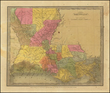
One of the First Coast to Coast Maps of the United States Two Years Before The Louisiana Purchase
This map, drawn by L. Collin and published in Baudry des Lozieres' Voyage à la Louisiane, et sur le Continent de l'Amérique Septentrionale..., offers a detailed depiction of the region now known as the United States as understood in the early 19th century.
The map spans nearly the entire present-day United States. East of the Mississippi River, states are labeled but not intricately engraved, whereas to the west, numerous Indian tribes are identified across the Plains region, with a massive open. The map marks the lands west of the Continental Divide as "n'est pas encore connu" (not yet known), highlighting the limited European knowledge of these regions at the time. This is particularly notable in the area between the Rocky Mountains and the Pacific, where the map is mostly blank except for some place names along the Pacific coast. The legend "l'intérieur de cette vaste contrée n'est pas encore connu" indicates the vast, unexplored expanse of the Great Basin just before the Louisiana Purchase.
Published on the cusp of the Louisiana Purchase, this map captures a pivotal moment in North American history. It serves as a crucial document for understanding the extent of European knowledge and the gaps therein just before a significant territorial expansion.